Schlotheim geodata
Schlotheim (Thuringia) is a populated place; located in Germany in Europe/Berlin (GMT+2) time zone. With population of 4,288 people, there are 3138 cities with bigger population in this country. Compared to other cities in Germany, 62.3% of cities are located further ↓South; 61.8% of cities are located further ←West and 52.3% of cities have lower elevation than Schlotheim. Note1


Schlotheim GPS coordinates[2]
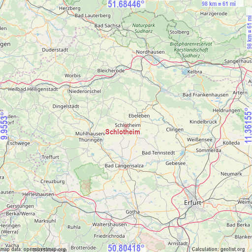
51° 14' 47.148" North, 10° 39' 30.312" East
| Map corner | latitude | longitude |
|---|---|---|
| Upper-left | 51.68446°, | 9.9553° |
| Center: | 51.24643°, | 10.65842° |
| Lower-right: | 50.80418°, | 11.36155° |
| Map W x H: | 97.9×97.9 km | = 60.8×60.8mi |
| max Lat: | 55.01917° ⇑37.7% North |
| Schlotheim: | 51.24643° |
| min Lat: | ⇓62.3% South 47.40724° |
| min Long | Schlotheim | max Long |
| 5.92978° | 10.65842° | 14.98853° |
| W 61.8%⇐ | ⇒38.2% E |
Elevation
Elevation of Schlotheim is 242 m = 794 ft, and this is 7.1 m = 23 ft below average elevation for this country.
| Max E: |
1256 m = 4121 ft | 47.7% |
| Avg. | 249.1 m = 817 ft | |
| Schlotheim | 242 m = 794 ft | |
Min E: |
-5 m = -16 ft | 52.3% |
See also: Germany elevation on elevation.city.
Geographical zone
Schlotheim is located in North temperate zone (between Tropic of Cancer and the Arctic Circle). Distance of this North polar circle is 1703.1 km =1058.3 mi to North.| Distance of | km | miles | from Schlotheim |
|---|---|---|---|
| North Pole | 4309 | 2677.5 | to North |
| Arctic Circle | 1703.1 | 1058.3 | to North |
| Tropic Cancer | 3092.1 | 1921.3 | to South |
| Equator | 5698.1 | 3540.6 | to South |


Nearby cities:
15 places around Schlotheim: (largest is in red/bold)
• Abtsbessingen
7.5 km =4.7 mi,  77°
77°
• Blankenburg
8.2 km =5.1 mi,  128°
128°
• Bothenheilingen
7.6 km =4.7 mi,  202°
202°
• Ebeleben
6.4 km =4 mi,  50°
50°
• Freienbessingen
7.7 km =4.8 mi,  100°
100°
• Holzsußra
4.5 km =2.8 mi,  22°
22°
• Issersheilingen
5.2 km =3.2 mi,  186°
186°
• Kirchheilingen
8 km =5 mi,  153°
153°
• Kleinwelsbach
7 km =4.3 mi,  175°
175°
• Kutzleben
8.2 km =5.1 mi, 128°
• Körner
5.1 km =3.2 mi,  250°
250°
• Marolterode
2.3 km =1.4 mi, 130°
• Neunheilingen
6.1 km =3.8 mi,  168°
168°
• Obermehler
5 km =3.1 mi,  301°
301°
• Urbach
6.5 km =4 mi,  325°
325°
Sources, notices
• [Note1] Compared only with cities in Germany existing in our database
• [Src1] Map data: © OpenStreetMap contributors (CC-BY-SA)
• [Src2] Other city data from geonames.org with taken over terms of usage.
• [Src3] Geographical zone / Annual Mean Temperature by Robert A. Rohde @ Wikipedia
