Körner geodata
Körner (Thuringia) is a seat of a fourth-order administrative division; located in Germany in Europe/Berlin (GMT+2) time zone. With population of 1,923 people, there are 5177 cities with bigger population in this country. Compared to other cities in Germany, 62% of cities are located further ↓South; 60.5% of cities are located further ←West and 50.7% of cities have higher elevation than Körner. Note1


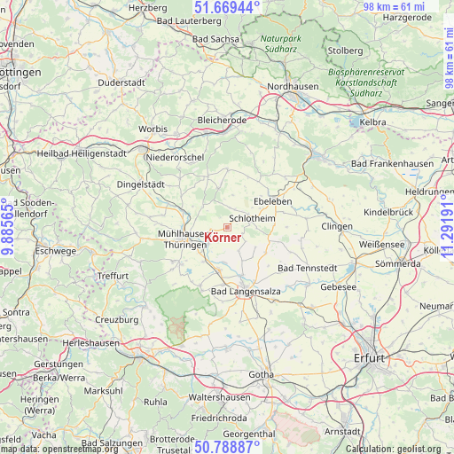
Körner GPS coordinates[2]
51° 13' 52.536" North, 10° 35' 19.608" East
| Map corner | latitude | longitude |
|---|---|---|
| Upper-left | 51.66944°, | 9.88565° |
| Center: | 51.23126°, | 10.58878° |
| Lower-right: | 50.78887°, | 11.29191° |
| Map W x H: | 97.9×97.9 km | = 60.8×60.8mi |
| max Lat: | 55.01917° ⇑38% North |
| Körner: | 51.23126° |
| min Lat: | ⇓62% South 47.40724° |
| min Long | Körner | max Long |
| 5.92978° | 10.58878° | 14.98853° |
| W 60.5%⇐ | ⇒39.5% E |
Elevation
Elevation of Körner is 220 m = 722 ft, and this is 29.1 m = 95 ft below average elevation for this country.
| Max E: |
1256 m = 4121 ft | 50.7% |
| Avg. | 249.1 m = 817 ft | |
| Körner | 220 m = 722 ft | |
Min E: |
-5 m = -16 ft | 49.3% |
See also: Germany elevation on elevation.city.
Geographical zone
Körner is located in North temperate zone (between Tropic of Cancer and the Arctic Circle). Distance of this North polar circle is 1704.8 km =1059.3 mi to North.| Distance of | km | miles | from Körner |
|---|---|---|---|
| North Pole | 4310.7 | 2678.5 | to North |
| Arctic Circle | 1704.8 | 1059.3 | to North |
| Tropic Cancer | 3090.5 | 1920.3 | to South |
| Equator | 5696.4 | 3539.6 | to South |


Nearby cities:
15 places around Körner: (largest is in red/bold)
• Altengottern
7.5 km =4.7 mi,  184°
184°
• Bothenheilingen
5.7 km =3.5 mi,  159°
159°
• Großengottern
9.4 km =5.8 mi,  191°
191°
• Holzsußra
8.8 km =5.5 mi,  48°
48°
• Issersheilingen
5.5 km =3.4 mi,  129°
129°
• Kirchheilingen
10 km =6.2 mi,  123°
123°
• Kleinwelsbach
7.6 km =4.7 mi, 134°
• Marolterode
6.6 km =4.1 mi,  87°
87°
• Menteroda
8.7 km =5.4 mi,  348°
348°
• Mühlhausen
9.8 km =6.1 mi,  255°
255°
• Neunheilingen
7.4 km =4.6 mi, 125°
• Obermehler
4.3 km =2.7 mi,  8°
8°
• Schlotheim
5.1 km =3.2 mi,  70°
70°
• Seebach
9 km =5.6 mi,  215°
215°
• Urbach
7.1 km =4.4 mi, 9°
Sources, notices
• [Note1] Compared only with cities in Germany existing in our database
• [Src1] Map data: © OpenStreetMap contributors (CC-BY-SA)
• [Src2] Other city data from geonames.org with taken over terms of usage.
• [Src3] Geographical zone / Annual Mean Temperature by Robert A. Rohde @ Wikipedia
