Schlesen geodata
Schlesen (Schleswig-Holstein) is a seat of a fourth-order administrative division; located in Germany in Europe/Berlin (GMT+2) time zone. With population of 555 people, there are 9057 cities with bigger population in this country. Compared to other cities in Germany, 96.6% of cities are located further ↓South; 56.1% of cities are located further ←West and 87.3% of cities have higher elevation than Schlesen. Note1


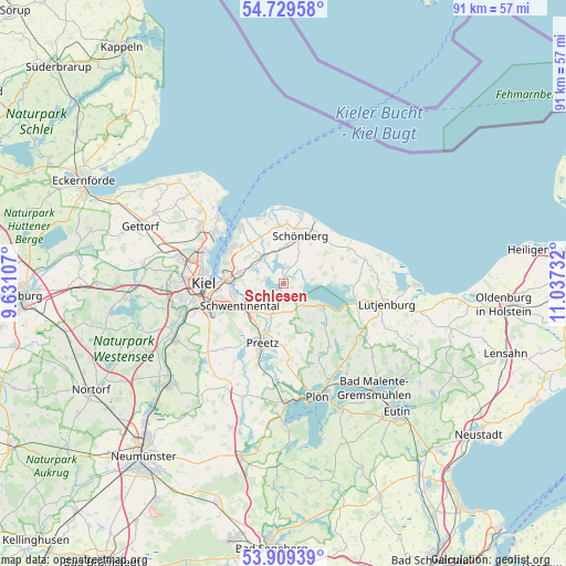
Schlesen GPS coordinates[2]
54° 19' 17.508" North, 10° 20' 3.084" East
| Map corner | latitude | longitude |
|---|---|---|
| Upper-left | 54.72958°, | 9.63107° |
| Center: | 54.32153°, | 10.33419° |
| Lower-right: | 53.90939°, | 11.03732° |
| Map W x H: | 91.2×91.2 km | = 56.7×56.7mi |
| max Lat: | 55.01917° ⇑3.4% North |
| Schlesen: | 54.32153° |
| min Lat: | ⇓96.6% South 47.40724° |
| min Long | Schlesen | max Long |
| 5.92978° | 10.33419° | 14.98853° |
| W 56.1%⇐ | ⇒43.9% E |
Elevation
Elevation of Schlesen is 29 m = 95 ft, and this is 220.1 m = 722 ft below average elevation for this country.
| Max E: |
1256 m = 4121 ft | 87.3% |
| Avg. | 249.1 m = 817 ft | |
| Schlesen | 29 m = 95 ft | |
Min E: |
-5 m = -16 ft | 12.7% |
See also: Germany elevation on elevation.city.
Geographical zone
Schlesen is located in North temperate zone (between Tropic of Cancer and the Arctic Circle). Distance of this North polar circle is 1361.2 km =845.8 mi to North.| Distance of | km | miles | from Schlesen |
|---|---|---|---|
| North Pole | 3967.1 | 2465 | to North |
| Arctic Circle | 1361.2 | 845.8 | to North |
| Tropic Cancer | 3434.1 | 2133.9 | to South |
| Equator | 6040 | 3753.1 | to South |


Nearby cities:
15 places around Schlesen: (largest is in red/bold)
• Bendfeld
7.3 km =4.5 mi,  46°
46°
• Dobersdorf
3.5 km =2.2 mi,  265°
265°
• Fahren
3.2 km =2 mi,  358°
358°
• Fargau-Pratjau
5.5 km =3.4 mi,  76°
76°
• Fiefbergen
6.9 km =4.3 mi,  8°
8°
• Höhndorf
5.4 km =3.4 mi,  22°
22°
• Martensrade
6 km =3.7 mi,  134°
134°
• Passade
5.1 km =3.2 mi,  347°
347°
• Prasdorf
7.2 km =4.5 mi,  342°
342°
• Probsteierhagen
5.4 km =3.4 mi,  325°
325°
• Raisdorf
7.1 km =4.4 mi,  230°
230°
• Rastorf
6.9 km =4.3 mi,  208°
208°
• Schönkirchen
6.7 km =4.2 mi,  281°
281°
• Selent
7 km =4.3 mi,  121°
121°
• Stoltenberg
3.3 km =2.1 mi, 17°
Sources, notices
• [Note1] Compared only with cities in Germany existing in our database
• [Src1] Map data: © OpenStreetMap contributors (CC-BY-SA)
• [Src2] Other city data from geonames.org with taken over terms of usage.
• [Src3] Geographical zone / Annual Mean Temperature by Robert A. Rohde @ Wikipedia
