Raisdorf geodata
Raisdorf (Schleswig-Holstein) is a populated place; located in Germany in Europe/Berlin (GMT+2) time zone. With population of 7,611 people, there are 2038 cities with bigger population in this country. Compared to other cities in Germany, 96% of cities are located further ↓South; 54.3% of cities are located further ←West and 88.6% of cities have higher elevation than Raisdorf. Note1


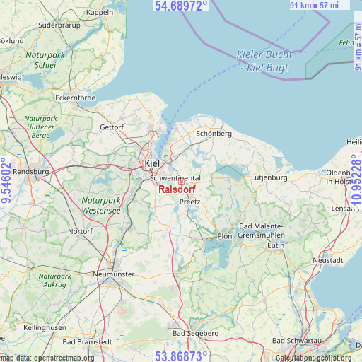
Raisdorf GPS coordinates[2]
54° 16' 52.572" North, 10° 14' 56.94" East
| Map corner | latitude | longitude |
|---|---|---|
| Upper-left | 54.68972°, | 9.54602° |
| Center: | 54.28127°, | 10.24915° |
| Lower-right: | 53.86873°, | 10.95228° |
| Map W x H: | 91.3×91.3 km | = 56.7×56.7mi |
| max Lat: | 55.01917° ⇑4% North |
| Raisdorf: | 54.28127° |
| min Lat: | ⇓96% South 47.40724° |
| min Long | Raisdorf | max Long |
| 5.92978° | 10.24915° | 14.98853° |
| W 54.3%⇐ | ⇒45.7% E |
Elevation
Elevation of Raisdorf is 25 m = 82 ft, and this is 224.1 m = 735 ft below average elevation for this country.
| Max E: |
1256 m = 4121 ft | 88.6% |
| Avg. | 249.1 m = 817 ft | |
| Raisdorf | 25 m = 82 ft | |
Min E: |
-5 m = -16 ft | 11.4% |
See also: Germany elevation on elevation.city.
Geographical zone
Raisdorf is located in North temperate zone (between Tropic of Cancer and the Arctic Circle). Distance of this North polar circle is 1365.7 km =848.6 mi to North.| Distance of | km | miles | from Raisdorf |
|---|---|---|---|
| North Pole | 3971.6 | 2467.8 | to North |
| Arctic Circle | 1365.7 | 848.6 | to North |
| Tropic Cancer | 3429.6 | 2131.1 | to South |
| Equator | 6035.5 | 3750.3 | to South |


Nearby cities:
15 places around Raisdorf: (largest is in red/bold)
• Dobersdorf
4.6 km =2.9 mi,  25°
25°
• Großbarkau
7.6 km =4.7 mi,  225°
225°
• Honigsee
6.8 km =4.2 mi,  218°
218°
• Kiel
8.6 km =5.3 mi,  300°
300°
• Klausdorf
3.8 km =2.4 mi,  323°
323°
• Klein Barkau
9.2 km =5.7 mi, 234°
• Kühren
9.2 km =5.7 mi,  175°
175°
• Mönkeberg
8.8 km =5.5 mi,  330°
330°
• Pohnsdorf
4.6 km =2.9 mi, 180°
• Postfeld
8.2 km =5.1 mi,  196°
196°
• Preetz
5.4 km =3.4 mi,  159°
159°
• Rastorf
2.7 km =1.7 mi,  126°
126°
• Schellhorn
6.5 km =4 mi,  153°
153°
• Schlesen
7.1 km =4.4 mi,  50°
50°
• Schönkirchen
5.9 km =3.7 mi,  349°
349°
Sources, notices
• [Note1] Compared only with cities in Germany existing in our database
• [Src1] Map data: © OpenStreetMap contributors (CC-BY-SA)
• [Src2] Other city data from geonames.org with taken over terms of usage.
• [Src3] Geographical zone / Annual Mean Temperature by Robert A. Rohde @ Wikipedia
