Scheuerfeld geodata
Scheuerfeld (Rheinland-Pfalz) is a seat of a fourth-order administrative division; located in Germany in Europe/Berlin (GMT+2) time zone. With population of 2,166 people, there are 4849 cities with bigger population in this country. Compared to other cities in Germany, 54% of cities are located further ↓South; 80.1% of cities are located further →East and 53.5% of cities have higher elevation than Scheuerfeld. Note1
Administrative division(s):
- Level 1: Rheinland-Pfalz
- Level 3: Landkreis Altenkirchen
- Level 4: Scheuerfeld


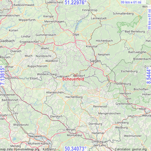
Scheuerfeld GPS coordinates[2]
50° 47' 14.496" North, 7° 50' 28.608" East
| Map corner | latitude | longitude |
|---|---|---|
| Upper-left | 51.22976°, | 7.13815° |
| Center: | 50.78736°, | 7.84128° |
| Lower-right: | 50.34073°, | 8.5444° |
| Map W x H: | 98.9×98.8 km | = 61.5×61.4mi |
| max Lat: | 55.01917° ⇑46% North |
| Scheuerfeld: | 50.78736° |
| min Lat: | ⇓54% South 47.40724° |
| min Long | Scheuerfeld | max Long |
| 5.92978° | 7.84128° | 14.98853° |
| W 19.9%⇐ | ⇒80.1% E |
Elevation
Elevation of Scheuerfeld is 200 m = 656 ft, and this is 49.1 m = 161 ft below average elevation for this country.
| Max E: |
1256 m = 4121 ft | 53.5% |
| Avg. | 249.1 m = 817 ft | |
| Scheuerfeld | 200 m = 656 ft | |
Min E: |
-5 m = -16 ft | 46.5% |
See also: Germany elevation on elevation.city.
Geographical zone
Scheuerfeld is located in North temperate zone (between Tropic of Cancer and the Arctic Circle). Distance of this North polar circle is 1754.1 km =1089.9 mi to North.| Distance of | km | miles | from Scheuerfeld |
|---|---|---|---|
| North Pole | 4360 | 2709.2 | to North |
| Arctic Circle | 1754.1 | 1089.9 | to North |
| Tropic Cancer | 3041.1 | 1889.7 | to South |
| Equator | 5647 | 3508.9 | to South |


Nearby cities:
15 places around Scheuerfeld: (largest is in red/bold)
• Alsdorf
3.3 km =2.1 mi,  109°
109°
• Betzdorf
2.2 km =1.4 mi,  79°
79°
• Dickendorf
6 km =3.7 mi,  174°
174°
• Elben
4.2 km =2.6 mi,  187°
187°
• Elkenroth
6.7 km =4.2 mi,  153°
153°
• Gebhardshain
4.5 km =2.8 mi,  202°
202°
• Grünebach
4.2 km =2.6 mi,  96°
96°
• Katzwinkel
3.3 km =2.1 mi,  336°
336°
• Kausen
5.4 km =3.4 mi,  160°
160°
• Kirchen
3.9 km =2.4 mi,  53°
53°
• Mittelhof
2.9 km =1.8 mi,  242°
242°
• Molzhain
4.2 km =2.6 mi, 171°
• Schutzbach
5.9 km =3.7 mi,  135°
135°
• Steineroth
3.1 km =1.9 mi, 162°
• Wallmenroth
1.5 km =0.9 mi, 338°
Sources, notices
• [Note1] Compared only with cities in Germany existing in our database
• [Src1] Map data: © OpenStreetMap contributors (CC-BY-SA)
• [Src2] Other city data from geonames.org with taken over terms of usage.
• [Src3] Geographical zone / Annual Mean Temperature by Robert A. Rohde @ Wikipedia
