Alsdorf geodata
Alsdorf (Rheinland-Pfalz) is a seat of a fourth-order administrative division; located in Germany in Europe/Berlin (GMT+2) time zone. With population of 1,765 people, there are 5405 cities with bigger population in this country. Compared to other cities in Germany, 53.8% of cities are located further ↓South; 79.2% of cities are located further →East and 54.1% of cities have higher elevation than Alsdorf. Note1
Administrative division(s):
- Level 1: Rheinland-Pfalz
- Level 3: Landkreis Altenkirchen
- Level 4: Alsdorf


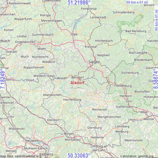
Alsdorf GPS coordinates[2]
50° 46' 38.496" North, 7° 53' 8.232" East
| Map corner | latitude | longitude |
|---|---|---|
| Upper-left | 51.21986°, | 7.18249° |
| Center: | 50.77736°, | 7.88562° |
| Lower-right: | 50.33063°, | 8.58874° |
| Map W x H: | 98.9×98.9 km | = 61.5×61.5mi |
| max Lat: | 55.01917° ⇑46.2% North |
| Alsdorf: | 50.77736° |
| min Lat: | ⇓53.8% South 47.40724° |
| min Long | Alsdorf | max Long |
| 5.92978° | 7.88562° | 14.98853° |
| W 20.8%⇐ | ⇒79.2% E |
Elevation
Elevation of Alsdorf is 196 m = 643 ft, and this is 53.1 m = 174 ft below average elevation for this country.
| Max E: |
1256 m = 4121 ft | 54.1% |
| Avg. | 249.1 m = 817 ft | |
| Alsdorf | 196 m = 643 ft | |
Min E: |
-5 m = -16 ft | 45.9% |
See also: Germany elevation on elevation.city.
Geographical zone
Alsdorf is located in North temperate zone (between Tropic of Cancer and the Arctic Circle). Distance of this North polar circle is 1755.3 km =1090.7 mi to North.| Distance of | km | miles | from Alsdorf |
|---|---|---|---|
| North Pole | 4361.1 | 2709.9 | to North |
| Arctic Circle | 1755.3 | 1090.7 | to North |
| Tropic Cancer | 3040 | 1889 | to South |
| Equator | 5645.9 | 3508.2 | to South |


Nearby cities:
15 places around Alsdorf: (largest is in red/bold)
• Betzdorf
1.8 km =1.1 mi,  327°
327°
• Brachbach
5.5 km =3.4 mi,  37°
37°
• Dickendorf
5.5 km =3.4 mi,  207°
207°
• Elben
4.8 km =3 mi,  230°
230°
• Elkenroth
4.9 km =3 mi,  181°
181°
• Grünebach
1.2 km =0.7 mi,  56°
56°
• Herdorf
4.8 km =3 mi,  90°
90°
• Kausen
4.2 km =2.6 mi,  197°
197°
• Kirchen
3.5 km =2.2 mi,  0°
0°
• Molzhain
3.9 km =2.4 mi,  219°
219°
• Niederdreisbach
4.1 km =2.5 mi,  139°
139°
• Scheuerfeld
3.3 km =2.1 mi,  289°
289°
• Schutzbach
3.2 km =2 mi,  161°
161°
• Steineroth
2.9 km =1.8 mi, 229°
• Wallmenroth
4.5 km =2.8 mi,  304°
304°
Sources, notices
• [Note1] Compared only with cities in Germany existing in our database
• [Src1] Map data: © OpenStreetMap contributors (CC-BY-SA)
• [Src2] Other city data from geonames.org with taken over terms of usage.
• [Src3] Geographical zone / Annual Mean Temperature by Robert A. Rohde @ Wikipedia
