Scheidegg geodata
Scheidegg (Bavaria) is a populated place; located in Germany in Europe/Berlin (GMT+2) time zone. With population of 4,198 people, there are 3177 cities with bigger population in this country. Compared to other cities in Germany, 99.7% of cities are located further ↑North; 52.2% of cities are located further →East and 99.2% of cities have lower elevation than Scheidegg. Note1
Administrative division(s):
- Level 1: Bavaria
- Level 2: Swabia
- Level 3: Landkreis Lindau
- Level 4: Scheidegg, Markt


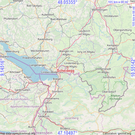
Scheidegg GPS coordinates[2]
47° 34' 53.076" North, 9° 50' 53.844" East
| Map corner | latitude | longitude |
|---|---|---|
| Upper-left | 48.05355°, | 9.14516° |
| Center: | 47.58141°, | 9.84829° |
| Lower-right: | 47.10497°, | 10.55142° |
| Map W x H: | 105.5×105.5 km | = 65.6×65.6mi |
| max Lat: | 55.01917° ⇑99.7% North |
| Scheidegg: | 47.58141° |
| min Lat: | ⇓0.3% South 47.40724° |
| min Long | Scheidegg | max Long |
| 5.92978° | 9.84829° | 14.98853° |
| W 47.8%⇐ | ⇒52.2% E |
Elevation
Elevation of Scheidegg is 805 m = 2641 ft, and this is 555.9 m = 1824 ft above average elevation for this country.
| Max E: |
1256 m = 4121 ft | 0.8% |
| Scheidegg | 805 m 2641 ft | |
| Avg. | 249.1 m = 817 ft | |
Min E: |
-5 m = -16 ft | 99.2% |
See also: Germany elevation on elevation.city.
Geographical zone
Scheidegg is located in North temperate zone (between Tropic of Cancer and the Arctic Circle). Distance of this North polar circle is 2110.6 km =1311.5 mi to North.| Distance of | km | miles | from Scheidegg |
|---|---|---|---|
| North Pole | 4716.5 | 2930.7 | to North |
| Arctic Circle | 2110.6 | 1311.5 | to North |
| Tropic Cancer | 2684.6 | 1668.1 | to South |
| Equator | 5290.6 | 3287.4 | to South |


Nearby cities:
15 places around Scheidegg: (largest is in red/bold)
• Gestratz
12.7 km =7.9 mi,  53°
53°
• Grünenbach
13.1 km =8.1 mi,  66°
66°
• Heimenkirch
6.7 km =4.2 mi,  37°
37°
• Hergatz
7.7 km =4.8 mi,  351°
351°
• Hergensweiler
6.3 km =3.9 mi,  308°
308°
• Lindau
12.9 km =8 mi,  252°
252°
• Niederwangen
10.7 km =6.6 mi,  339°
339°
• Oberreute
7.5 km =4.7 mi,  105°
105°
• Opfenbach
5.9 km =3.7 mi, 349°
• Röthenbach
10.5 km =6.5 mi,  63°
63°
• Sigmarszell
6.1 km =3.8 mi,  271°
271°
• Stiefenhofen
11.7 km =7.3 mi,  83°
83°
• Wangen
12.1 km =7.5 mi, 354°
• Weiler-Simmerberg
4.9 km =3 mi,  88°
88°
• Weißensberg
9.2 km =5.7 mi, 269°
Sources, notices
• [Note1] Compared only with cities in Germany existing in our database
• [Src1] Map data: © OpenStreetMap contributors (CC-BY-SA)
• [Src2] Other city data from geonames.org with taken over terms of usage.
• [Src3] Geographical zone / Annual Mean Temperature by Robert A. Rohde @ Wikipedia
