Grünenbach geodata
Grünenbach (Bavaria) is a seat of a fourth-order administrative division; located in Germany in Europe/Berlin (GMT+2) time zone. With population of 1,364 people, there are 6154 cities with bigger population in this country. Compared to other cities in Germany, 99.4% of cities are located further ↑North; 50.2% of cities are located further ←West and 98.1% of cities have lower elevation than Grünenbach. Note1
Administrative division(s):
- Level 1: Bavaria
- Level 2: Swabia
- Level 3: Landkreis Lindau
- Level 4: Grünenbach


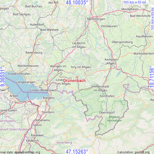
Grünenbach GPS coordinates[2]
47° 37' 43.104" North, 10° 0' 30.348" East
| Map corner | latitude | longitude |
|---|---|---|
| Upper-left | 48.10035°, | 9.30531° |
| Center: | 47.62864°, | 10.00843° |
| Lower-right: | 47.15263°, | 10.71156° |
| Map W x H: | 105.4×105.4 km | = 65.5×65.5mi |
| max Lat: | 55.01917° ⇑99.4% North |
| Grünenbach: | 47.62864° |
| min Lat: | ⇓0.6% South 47.40724° |
| min Long | Grünenbach | max Long |
| 5.92978° | 10.00843° | 14.98853° |
| W 50.2%⇐ | ⇒49.8% E |
Elevation
Elevation of Grünenbach is 716 m = 2349 ft, and this is 466.9 m = 1532 ft above average elevation for this country.
| Max E: |
1256 m = 4121 ft | 1.9% |
| Grünenbach | 716 m 2349 ft | |
| Avg. | 249.1 m = 817 ft | |
Min E: |
-5 m = -16 ft | 98.1% |
See also: Germany elevation on elevation.city.
Geographical zone
Grünenbach is located in North temperate zone (between Tropic of Cancer and the Arctic Circle). Distance of this North polar circle is 2105.4 km =1308.2 mi to North.| Distance of | km | miles | from Grünenbach |
|---|---|---|---|
| North Pole | 4711.3 | 2927.5 | to North |
| Arctic Circle | 2105.4 | 1308.2 | to North |
| Tropic Cancer | 2689.9 | 1671.4 | to South |
| Equator | 5295.8 | 3290.7 | to South |


Nearby cities:
15 places around Grünenbach: (largest is in red/bold)
• Gestratz
3 km =1.9 mi,  321°
321°
• Heimenkirch
7.9 km =4.9 mi,  270°
270°
• Hergatz
13.3 km =8.3 mi,  280°
280°
• Isny
7.5 km =4.7 mi,  17°
17°
• Maierhöfen
3.9 km =2.4 mi,  52°
52°
• Missen-Wilhams
8.7 km =5.4 mi,  111°
111°
• Oberreute
8.7 km =5.4 mi,  213°
213°
• Oberstaufen
8.2 km =5.1 mi,  172°
172°
• Opfenbach
13.1 km =8.1 mi, 272°
• Röthenbach
2.7 km =1.7 mi,  256°
256°
• Scheidegg
13.1 km =8.1 mi,  246°
246°
• Stiefenhofen
4 km =2.5 mi,  185°
185°
• Wangen
14.8 km =9.2 mi,  297°
297°
• Weiler-Simmerberg
8.8 km =5.5 mi,  234°
234°
• Weitnau
9 km =5.6 mi,  80°
80°
Sources, notices
• [Note1] Compared only with cities in Germany existing in our database
• [Src1] Map data: © OpenStreetMap contributors (CC-BY-SA)
• [Src2] Other city data from geonames.org with taken over terms of usage.
• [Src3] Geographical zone / Annual Mean Temperature by Robert A. Rohde @ Wikipedia
