Oberreute geodata
Oberreute (Bavaria) is a seat of a fourth-order administrative division; located in Germany in Europe/Berlin (GMT+2) time zone. With population of 1,566 people, there are 5752 cities with bigger population in this country. Compared to other cities in Germany, 99.8% of cities are located further ↑North; 50.9% of cities are located further →East and 99.6% of cities have lower elevation than Oberreute. Note1
Administrative division(s):
- Level 1: Bavaria
- Level 2: Swabia
- Level 3: Landkreis Lindau
- Level 4: Oberreute


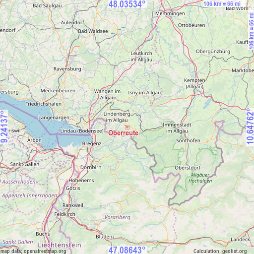
Oberreute GPS coordinates[2]
47° 33' 46.908" North, 9° 56' 40.164" East
| Map corner | latitude | longitude |
|---|---|---|
| Upper-left | 48.03534°, | 9.24137° |
| Center: | 47.56303°, | 9.94449° |
| Lower-right: | 47.08643°, | 10.64762° |
| Map W x H: | 105.5×105.5 km | = 65.6×65.6mi |
| max Lat: | 55.01917° ⇑99.8% North |
| Oberreute: | 47.56303° |
| min Lat: | ⇓0.2% South 47.40724° |
| min Long | Oberreute | max Long |
| 5.92978° | 9.94449° | 14.98853° |
| W 49.1%⇐ | ⇒50.9% E |
Elevation
Elevation of Oberreute is 856 m = 2808 ft, and this is 606.9 m = 1991 ft above average elevation for this country.
| Max E: |
1256 m = 4121 ft | 0.40000000000001% |
| Oberreute | 856 m 2808 ft | |
| Avg. | 249.1 m = 817 ft | |
Min E: |
-5 m = -16 ft | 99.6% |
See also: Germany elevation on elevation.city.
Geographical zone
Oberreute is located in North temperate zone (between Tropic of Cancer and the Arctic Circle). Distance of this North polar circle is 2112.7 km =1312.8 mi to North.| Distance of | km | miles | from Oberreute |
|---|---|---|---|
| North Pole | 4718.5 | 2931.9 | to North |
| Arctic Circle | 2112.7 | 1312.8 | to North |
| Tropic Cancer | 2682.6 | 1666.9 | to South |
| Equator | 5288.5 | 3286.1 | to South |


Nearby cities:
15 places around Oberreute: (largest is in red/bold)
• Balderschwang
15.8 km =9.8 mi,  132°
132°
• Gestratz
10.1 km =6.3 mi,  16°
16°
• Grünenbach
8.7 km =5.4 mi,  33°
33°
• Heimenkirch
8 km =5 mi,  337°
337°
• Hergatz
12.8 km =8 mi,  319°
319°
• Hergensweiler
13.5 km =8.4 mi,  296°
296°
• Maierhöfen
12.5 km =7.8 mi,  39°
39°
• Missen-Wilhams
13.6 km =8.5 mi,  72°
72°
• Oberstaufen
5.9 km =3.7 mi,  97°
97°
• Opfenbach
11.4 km =7.1 mi,  313°
313°
• Röthenbach
7 km =4.3 mi, 18°
• Scheidegg
7.5 km =4.7 mi,  285°
285°
• Sigmarszell
13.5 km =8.4 mi,  279°
279°
• Stiefenhofen
5.6 km =3.5 mi,  52°
52°
• Weiler-Simmerberg
3.2 km =2 mi, 313°
Sources, notices
• [Note1] Compared only with cities in Germany existing in our database
• [Src1] Map data: © OpenStreetMap contributors (CC-BY-SA)
• [Src2] Other city data from geonames.org with taken over terms of usage.
• [Src3] Geographical zone / Annual Mean Temperature by Robert A. Rohde @ Wikipedia
