Opfenbach geodata
Opfenbach (Bavaria) is a seat of a fourth-order administrative division; located in Germany in Europe/Berlin (GMT+2) time zone. With population of 2,260 people, there are 4725 cities with bigger population in this country. Compared to other cities in Germany, 99.4% of cities are located further ↑North; 52.4% of cities are located further →East and 93.5% of cities have lower elevation than Opfenbach. Note1
Administrative division(s):
- Level 1: Bavaria
- Level 2: Swabia
- Level 3: Landkreis Lindau
- Level 4: Opfenbach


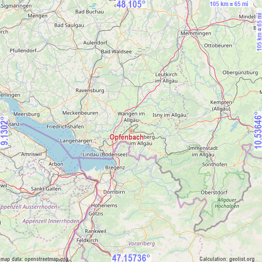
Opfenbach GPS coordinates[2]
47° 37' 59.988" North, 9° 49' 59.988" East
| Map corner | latitude | longitude |
|---|---|---|
| Upper-left | 48.105°, | 9.1302° |
| Center: | 47.63333°, | 9.83333° |
| Lower-right: | 47.15736°, | 10.53646° |
| Map W x H: | 105.4×105.4 km | = 65.5×65.5mi |
| max Lat: | 55.01917° ⇑99.4% North |
| Opfenbach: | 47.63333° |
| min Lat: | ⇓0.6% South 47.40724° |
| min Long | Opfenbach | max Long |
| 5.92978° | 9.83333° | 14.98853° |
| W 47.6%⇐ | ⇒52.4% E |
Elevation
Elevation of Opfenbach is 566 m = 1857 ft, and this is 316.9 m = 1040 ft above average elevation for this country.
| Max E: |
1256 m = 4121 ft | 6.5% |
| Opfenbach | 566 m 1857 ft | |
| Avg. | 249.1 m = 817 ft | |
Min E: |
-5 m = -16 ft | 93.5% |
See also: Germany elevation on elevation.city.
Geographical zone
Opfenbach is located in North temperate zone (between Tropic of Cancer and the Arctic Circle). Distance of this North polar circle is 2104.8 km =1307.9 mi to North.| Distance of | km | miles | from Opfenbach |
|---|---|---|---|
| North Pole | 4710.7 | 2927.1 | to North |
| Arctic Circle | 2104.8 | 1307.9 | to North |
| Tropic Cancer | 2690.4 | 1671.7 | to South |
| Equator | 5296.3 | 3291 | to South |


Nearby cities:
15 places around Opfenbach: (largest is in red/bold)
• Amtzell
9.7 km =6 mi,  319°
319°
• Gestratz
11.4 km =7.1 mi,  80°
80°
• Grünenbach
13.1 km =8.1 mi,  92°
92°
• Heimenkirch
5.2 km =3.2 mi, 94°
• Hergatz
1.9 km =1.2 mi,  0°
0°
• Hergensweiler
4.2 km =2.6 mi,  243°
243°
• Neukirch
10.1 km =6.3 mi,  285°
285°
• Niederwangen
5 km =3.1 mi,  328°
328°
• Oberreute
11.4 km =7.1 mi,  133°
133°
• Röthenbach
10.6 km =6.6 mi,  96°
96°
• Scheidegg
5.9 km =3.7 mi,  169°
169°
• Sigmarszell
7.5 km =4.7 mi,  221°
221°
• Wangen
6.2 km =3.9 mi,  359°
359°
• Weiler-Simmerberg
8.2 km =5.1 mi, 133°
• Weißensberg
9.9 km =6.2 mi,  234°
234°
Sources, notices
• [Note1] Compared only with cities in Germany existing in our database
• [Src1] Map data: © OpenStreetMap contributors (CC-BY-SA)
• [Src2] Other city data from geonames.org with taken over terms of usage.
• [Src3] Geographical zone / Annual Mean Temperature by Robert A. Rohde @ Wikipedia
