Satow-Oberhagen geodata
Satow-Oberhagen (Mecklenburg-Vorpommern) is a populated place; located in Germany in Europe/Berlin (GMT+2) time zone. With population of 5,895 people, there are 2493 cities with bigger population in this country. Compared to other cities in Germany, 92.6% of cities are located further ↓South; 80.1% of cities are located further ←West and 80.6% of cities have higher elevation than Satow-Oberhagen. Note1
Administrative division(s):
- Level 1: Mecklenburg-Vorpommern
- Level 3: Landkreis Rostock
- Level 4: Satow


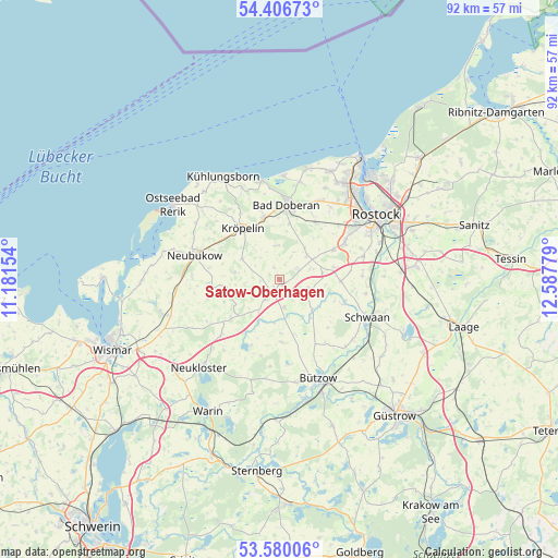
Satow-Oberhagen GPS coordinates[2]
53° 59' 43.62" North, 11° 53' 4.776" East
| Map corner | latitude | longitude |
|---|---|---|
| Upper-left | 54.40673°, | 11.18154° |
| Center: | 53.99545°, | 11.88466° |
| Lower-right: | 53.58006°, | 12.58779° |
| Map W x H: | 91.9×91.9 km | = 57.1×57.1mi |
| max Lat: | 55.01917° ⇑7.4% North |
| Satow-Oberhagen: | 53.99545° |
| min Lat: | ⇓92.6% South 47.40724° |
| min Long | Satow-Oberhagen | max Long |
| 5.92978° | 11.88466° | 14.98853° |
| W 80.1%⇐ | ⇒19.9% E |
Elevation
Elevation of Satow-Oberhagen is 45 m = 148 ft, and this is 204.1 m = 670 ft below average elevation for this country.
| Max E: |
1256 m = 4121 ft | 80.6% |
| Avg. | 249.1 m = 817 ft | |
| Satow-Oberhagen | 45 m = 148 ft | |
Min E: |
-5 m = -16 ft | 19.4% |
See also: Germany elevation on elevation.city.
Geographical zone
Satow-Oberhagen is located in North temperate zone (between Tropic of Cancer and the Arctic Circle). Distance of this North polar circle is 1397.4 km =868.3 mi to North.| Distance of | km | miles | from Satow-Oberhagen |
|---|---|---|---|
| North Pole | 4003.3 | 2487.5 | to North |
| Arctic Circle | 1397.4 | 868.3 | to North |
| Tropic Cancer | 3397.8 | 2111.3 | to South |
| Equator | 6003.7 | 3730.5 | to South |


Nearby cities:
15 places around Satow-Oberhagen: (largest is in red/bold)
• Bad Doberan
12.5 km =7.8 mi,  4°
4°
• Bartenshagen-Parkentin
11.3 km =7 mi,  32°
32°
• Bernitt
10.2 km =6.3 mi,  179°
179°
• Glasin
13.4 km =8.3 mi,  226°
226°
• Heiligenhagen
3.6 km =2.2 mi,  64°
64°
• Jennewitz
12.6 km =7.8 mi,  330°
330°
• Jürgenshagen
4.7 km =2.9 mi,  170°
170°
• Klein Belitz
8.3 km =5.2 mi,  140°
140°
• Kritzmow
12.7 km =7.9 mi, 60°
• Kröpelin
10.1 km =6.3 mi,  324°
324°
• Reddelich
10.6 km =6.6 mi,  347°
347°
• Retschow
5.6 km =3.5 mi,  355°
355°
• Steffenshagen
12.8 km =8 mi,  341°
341°
• Stäbelow
10.4 km =6.5 mi, 60°
• Ziesendorf
10.1 km =6.3 mi,  90°
90°
Sources, notices
• [Note1] Compared only with cities in Germany existing in our database
• [Src1] Map data: © OpenStreetMap contributors (CC-BY-SA)
• [Src2] Other city data from geonames.org with taken over terms of usage.
• [Src3] Geographical zone / Annual Mean Temperature by Robert A. Rohde @ Wikipedia
