Bernitt geodata
Bernitt (Mecklenburg-Vorpommern) is a populated place; located in Germany in Europe/Berlin (GMT+2) time zone. With population of 1,890 people, there are 5218 cities with bigger population in this country. Compared to other cities in Germany, 91.3% of cities are located further ↓South; 80.1% of cities are located further ←West and 78.7% of cities have higher elevation than Bernitt. Note1
Administrative division(s):
- Level 1: Mecklenburg-Vorpommern
- Level 3: Landkreis Rostock
- Level 4: Bernitt


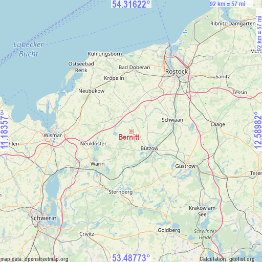
Bernitt GPS coordinates[2]
53° 54' 14.508" North, 11° 53' 12.084" East
| Map corner | latitude | longitude |
|---|---|---|
| Upper-left | 54.31622°, | 11.18357° |
| Center: | 53.90403°, | 11.88669° |
| Lower-right: | 53.48773°, | 12.58982° |
| Map W x H: | 92.1×92.1 km | = 57.2×57.2mi |
| max Lat: | 55.01917° ⇑8.7% North |
| Bernitt: | 53.90403° |
| min Lat: | ⇓91.3% South 47.40724° |
| min Long | Bernitt | max Long |
| 5.92978° | 11.88669° | 14.98853° |
| W 80.1%⇐ | ⇒19.9% E |
Elevation
Elevation of Bernitt is 51 m = 167 ft, and this is 198.1 m = 650 ft below average elevation for this country.
| Max E: |
1256 m = 4121 ft | 78.7% |
| Avg. | 249.1 m = 817 ft | |
| Bernitt | 51 m = 167 ft | |
Min E: |
-5 m = -16 ft | 21.3% |
See also: Germany elevation on elevation.city.
Geographical zone
Bernitt is located in North temperate zone (between Tropic of Cancer and the Arctic Circle). Distance of this North polar circle is 1407.6 km =874.6 mi to North.| Distance of | km | miles | from Bernitt |
|---|---|---|---|
| North Pole | 4013.5 | 2493.9 | to North |
| Arctic Circle | 1407.6 | 874.6 | to North |
| Tropic Cancer | 3387.6 | 2105 | to South |
| Equator | 5993.6 | 3724.2 | to South |


Nearby cities:
15 places around Bernitt: (largest is in red/bold)
• Bützow
8.8 km =5.5 mi,  134°
134°
• Glasin
9.9 km =6.2 mi,  275°
275°
• Gülzow
15.1 km =9.4 mi, 128°
• Heiligenhagen
12.1 km =7.5 mi,  15°
15°
• Horst
7.3 km =4.5 mi,  109°
109°
• Jürgenshagen
5.6 km =3.5 mi,  6°
6°
• Klein Belitz
6.4 km =4 mi,  53°
53°
• Lüdersdorf
9.9 km =6.2 mi,  246°
246°
• Neukloster
13.9 km =8.6 mi, 252°
• Rühn
9.9 km =6.2 mi,  159°
159°
• Satow-Oberhagen
10.2 km =6.3 mi,  359°
359°
• Schwaan
15 km =9.3 mi,  74°
74°
• Warnow
13.2 km =8.2 mi,  181°
181°
• Zepelin
13 km =8.1 mi, 126°
• Ziesendorf
14.2 km =8.8 mi,  44°
44°
Sources, notices
• [Note1] Compared only with cities in Germany existing in our database
• [Src1] Map data: © OpenStreetMap contributors (CC-BY-SA)
• [Src2] Other city data from geonames.org with taken over terms of usage.
• [Src3] Geographical zone / Annual Mean Temperature by Robert A. Rohde @ Wikipedia
