Heiligenhagen geodata
Heiligenhagen (Mecklenburg-Vorpommern) is a populated place; located in Germany in Europe/Berlin (GMT+2) time zone. With population of 824 people, there are 7807 cities with bigger population in this country. Compared to other cities in Germany, 92.8% of cities are located further ↓South; 80.9% of cities are located further ←West and 84.9% of cities have higher elevation than Heiligenhagen. Note1
Administrative division(s):
- Level 1: Mecklenburg-Vorpommern
- Level 3: Landkreis Rostock
- Level 4: Satow


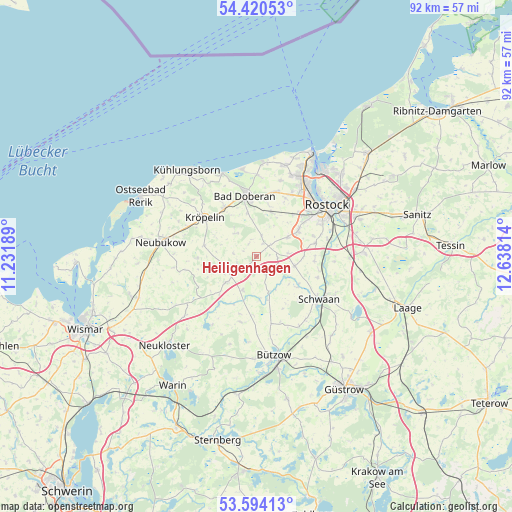
Heiligenhagen GPS coordinates[2]
54° 0' 33.768" North, 11° 56' 6.036" East
| Map corner | latitude | longitude |
|---|---|---|
| Upper-left | 54.42053°, | 11.23189° |
| Center: | 54.00938°, | 11.93501° |
| Lower-right: | 53.59413°, | 12.63814° |
| Map W x H: | 91.9×91.9 km | = 57.1×57.1mi |
| max Lat: | 55.01917° ⇑7.2% North |
| Heiligenhagen: | 54.00938° |
| min Lat: | ⇓92.8% South 47.40724° |
| min Long | Heiligenhagen | max Long |
| 5.92978° | 11.93501° | 14.98853° |
| W 80.9%⇐ | ⇒19.1% E |
Elevation
Elevation of Heiligenhagen is 35 m = 115 ft, and this is 214.1 m = 702 ft below average elevation for this country.
| Max E: |
1256 m = 4121 ft | 84.9% |
| Avg. | 249.1 m = 817 ft | |
| Heiligenhagen | 35 m = 115 ft | |
Min E: |
-5 m = -16 ft | 15.1% |
See also: Germany elevation on elevation.city.
Geographical zone
Heiligenhagen is located in North temperate zone (between Tropic of Cancer and the Arctic Circle). Distance of this North polar circle is 1395.9 km =867.4 mi to North.| Distance of | km | miles | from Heiligenhagen |
|---|---|---|---|
| North Pole | 4001.8 | 2486.6 | to North |
| Arctic Circle | 1395.9 | 867.4 | to North |
| Tropic Cancer | 3399.4 | 2112.3 | to South |
| Equator | 6005.3 | 3731.5 | to South |


Nearby cities:
15 places around Heiligenhagen: (largest is in red/bold)
• Bad Doberan
11.1 km =6.9 mi,  348°
348°
• Bartenshagen-Parkentin
8.5 km =5.3 mi,  19°
19°
• Bernitt
12.1 km =7.5 mi,  195°
195°
• Jürgenshagen
6.6 km =4.1 mi, 202°
• Klein Belitz
8.2 km =5.1 mi,  165°
165°
• Kritzmow
9.1 km =5.7 mi,  58°
58°
• Kröpelin
11.3 km =7 mi,  306°
306°
• Lambrechtshagen
11.6 km =7.2 mi,  27°
27°
• Papendorf
13.2 km =8.2 mi,  77°
77°
• Reddelich
10.4 km =6.5 mi,  328°
328°
• Retschow
5.5 km =3.4 mi,  317°
317°
• Satow-Oberhagen
3.6 km =2.2 mi,  244°
244°
• Steffenshagen
12.9 km =8 mi, 325°
• Stäbelow
6.8 km =4.2 mi, 58°
• Ziesendorf
7 km =4.3 mi,  103°
103°
Sources, notices
• [Note1] Compared only with cities in Germany existing in our database
• [Src1] Map data: © OpenStreetMap contributors (CC-BY-SA)
• [Src2] Other city data from geonames.org with taken over terms of usage.
• [Src3] Geographical zone / Annual Mean Temperature by Robert A. Rohde @ Wikipedia
