Reddelich geodata
Reddelich (Mecklenburg-Vorpommern) is a populated place; located in Germany in Europe/Berlin (GMT+2) time zone. With population of 896 people, there are 7537 cities with bigger population in this country. Compared to other cities in Germany, 93.8% of cities are located further ↓South; 79.6% of cities are located further ←West and 75% of cities have higher elevation than Reddelich. Note1
Administrative division(s):
- Level 1: Mecklenburg-Vorpommern
- Level 3: Landkreis Rostock
- Level 4: Reddelich


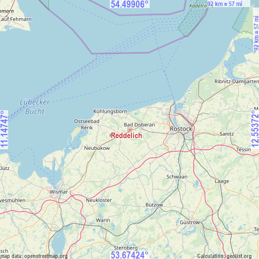
Reddelich GPS coordinates[2]
54° 5' 19.32" North, 11° 51' 2.124" East
| Map corner | latitude | longitude |
|---|---|---|
| Upper-left | 54.49906°, | 11.14747° |
| Center: | 54.0887°, | 11.85059° |
| Lower-right: | 53.67424°, | 12.55372° |
| Map W x H: | 91.7×91.7 km | = 57×57mi |
| max Lat: | 55.01917° ⇑6.2% North |
| Reddelich: | 54.0887° |
| min Lat: | ⇓93.8% South 47.40724° |
| min Long | Reddelich | max Long |
| 5.92978° | 11.85059° | 14.98853° |
| W 79.6%⇐ | ⇒20.4% E |
Elevation
Elevation of Reddelich is 63 m = 207 ft, and this is 186.1 m = 611 ft below average elevation for this country.
| Max E: |
1256 m = 4121 ft | 75% |
| Avg. | 249.1 m = 817 ft | |
| Reddelich | 63 m = 207 ft | |
Min E: |
-5 m = -16 ft | 25% |
See also: Germany elevation on elevation.city.
Geographical zone
Reddelich is located in North temperate zone (between Tropic of Cancer and the Arctic Circle). Distance of this North polar circle is 1387.1 km =861.9 mi to North.| Distance of | km | miles | from Reddelich |
|---|---|---|---|
| North Pole | 3993 | 2481.1 | to North |
| Arctic Circle | 1387.1 | 861.9 | to North |
| Tropic Cancer | 3408.2 | 2117.8 | to South |
| Equator | 6014.1 | 3737 | to South |


Nearby cities:
15 places around Reddelich: (largest is in red/bold)
• Admannshagen-Bargeshagen
10.7 km =6.6 mi,  64°
64°
• Bad Doberan
3.8 km =2.4 mi, 57°
• Bartenshagen-Parkentin
8.4 km =5.2 mi,  95°
95°
• Bastorf
10.8 km =6.7 mi,  292°
292°
• Biendorf
9.9 km =6.2 mi,  261°
261°
• Börgerende-Rethwisch
7.6 km =4.7 mi,  39°
39°
• Heiligenhagen
10.4 km =6.5 mi,  148°
148°
• Jennewitz
4 km =2.5 mi,  278°
278°
• Kröpelin
4.2 km =2.6 mi,  239°
239°
• Lambrechtshagen
10.9 km =6.8 mi,  82°
82°
• Ostseebad Kühlungsborn
9 km =5.6 mi,  319°
319°
• Retschow
5.1 km =3.2 mi,  159°
159°
• Satow-Oberhagen
10.6 km =6.6 mi,  167°
167°
• Steffenshagen
2.6 km =1.6 mi,  313°
313°
• Wittenbeck
5.6 km =3.5 mi, 312°
Sources, notices
• [Note1] Compared only with cities in Germany existing in our database
• [Src1] Map data: © OpenStreetMap contributors (CC-BY-SA)
• [Src2] Other city data from geonames.org with taken over terms of usage.
• [Src3] Geographical zone / Annual Mean Temperature by Robert A. Rohde @ Wikipedia
