Haslach geodata
Haslach (Baden-Württemberg) is a populated place; located in Germany in Europe/Berlin (GMT+2) time zone. With population of 6,874 people, there are 2209 cities with bigger population in this country. Compared to other cities in Germany, 88.3% of cities are located further ↑North; 76.2% of cities are located further →East and 56.5% of cities have higher elevation than Haslach. Note1
Administrative division(s):
- Level 1: Baden-Württemberg
- Level 2: Freiburg Region
- Level 3: Ortenaukreis
- Level 4: Oberkirch


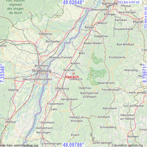
Haslach GPS coordinates[2]
48° 33' 55.116" North, 8° 3' 23.688" East
| Map corner | latitude | longitude |
|---|---|---|
| Upper-left | 49.02848°, | 7.35346° |
| Center: | 48.56531°, | 8.05658° |
| Lower-right: | 48.09786°, | 8.75971° |
| Map W x H: | 103.5×103.5 km | = 64.3×64.3mi |
| max Lat: | 55.01917° ⇑88.3% North |
| Haslach: | 48.56531° |
| min Lat: | ⇓11.7% South 47.40724° |
| min Long | Haslach | max Long |
| 5.92978° | 8.05658° | 14.98853° |
| W 23.8%⇐ | ⇒76.2% E |
Elevation
Elevation of Haslach is 178 m = 584 ft, and this is 71.1 m = 233 ft below average elevation for this country.
| Max E: |
1256 m = 4121 ft | 56.5% |
| Avg. | 249.1 m = 817 ft | |
| Haslach | 178 m = 584 ft | |
Min E: |
-5 m = -16 ft | 43.5% |
See also: Germany elevation on elevation.city.
Geographical zone
Haslach is located in North temperate zone (between Tropic of Cancer and the Arctic Circle). Distance of this North polar circle is 2001.2 km =1243.5 mi to North.| Distance of | km | miles | from Haslach |
|---|---|---|---|
| North Pole | 4607.1 | 2862.7 | to North |
| Arctic Circle | 2001.2 | 1243.5 | to North |
| Tropic Cancer | 2794 | 1736.1 | to South |
| Equator | 5400 | 3355.4 | to South |


Nearby cities:
15 places around Haslach: (largest is in red/bold)
• Achern
7.5 km =4.7 mi,  11°
11°
• Appenweier
6.5 km =4 mi,  236°
236°
• Durbach
8.5 km =5.3 mi,  199°
199°
• Kappelrodeck
5.3 km =3.3 mi,  56°
56°
• Lauf
11 km =6.8 mi,  30°
30°
• Lautenbach
6.6 km =4.1 mi,  139°
139°
• Lautenbach
9.5 km =5.9 mi,  193°
193°
• Oberkirch
4 km =2.5 mi,  156°
156°
• Ottenhöfen im Schwarzwald
6.9 km =4.3 mi,  88°
88°
• Ottersweier
12.4 km =7.7 mi,  19°
19°
• Renchen
4.1 km =2.5 mi,  308°
308°
• Sasbach
8.7 km =5.4 mi, 18°
• Sasbachwalden
8 km =5 mi,  44°
44°
• Seebach
8.5 km =5.3 mi,  81°
81°
• Willstätt
12.3 km =7.6 mi,  257°
257°
Sources, notices
• [Note1] Compared only with cities in Germany existing in our database
• [Src1] Map data: © OpenStreetMap contributors (CC-BY-SA)
• [Src2] Other city data from geonames.org with taken over terms of usage.
• [Src3] Geographical zone / Annual Mean Temperature by Robert A. Rohde @ Wikipedia
