Salzbergen geodata
Salzbergen (Lower Saxony) is a seat of a fourth-order administrative division; located in Germany in Europe/Berlin (GMT+2) time zone. With population of 7,602 people, there are 2042 cities with bigger population in this country. Compared to other cities in Germany, 75.5% of cities are located further ↓South; 89.3% of cities are located further →East and 86.6% of cities have higher elevation than Salzbergen. Note1


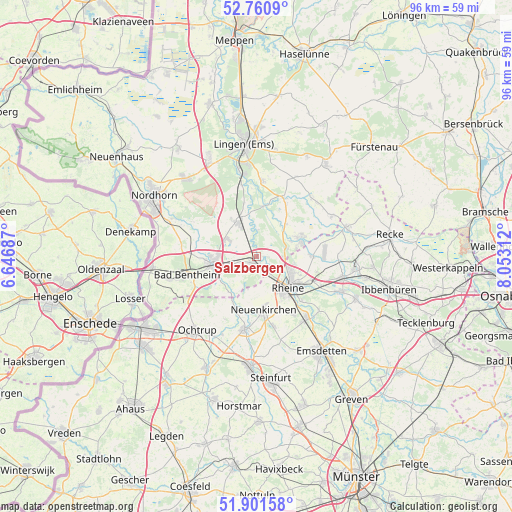
Salzbergen GPS coordinates[2]
52° 19' 59.988" North, 7° 21' 0" East
| Map corner | latitude | longitude |
|---|---|---|
| Upper-left | 52.7609°, | 6.64687° |
| Center: | 52.33333°, | 7.35° |
| Lower-right: | 51.90158°, | 8.05312° |
| Map W x H: | 95.5×95.5 km | = 59.3×59.3mi |
| max Lat: | 55.01917° ⇑24.5% North |
| Salzbergen: | 52.33333° |
| min Lat: | ⇓75.5% South 47.40724° |
| min Long | Salzbergen | max Long |
| 5.92978° | 7.35° | 14.98853° |
| W 10.7%⇐ | ⇒89.3% E |
Elevation
Elevation of Salzbergen is 31 m = 102 ft, and this is 218.1 m = 716 ft below average elevation for this country.
| Max E: |
1256 m = 4121 ft | 86.6% |
| Avg. | 249.1 m = 817 ft | |
| Salzbergen | 31 m = 102 ft | |
Min E: |
-5 m = -16 ft | 13.4% |
See also: Germany elevation on elevation.city.
Geographical zone
Salzbergen is located in North temperate zone (between Tropic of Cancer and the Arctic Circle). Distance of this North polar circle is 1582.3 km =983.2 mi to North.| Distance of | km | miles | from Salzbergen |
|---|---|---|---|
| North Pole | 4188.1 | 2602.4 | to North |
| Arctic Circle | 1582.3 | 983.2 | to North |
| Tropic Cancer | 3213 | 1996.5 | to South |
| Equator | 5818.9 | 3615.7 | to South |


Nearby cities:
15 places around Salzbergen: (largest is in red/bold)
• Bad Bentheim
13.6 km =8.5 mi,  254°
254°
• Dreierwalde
10.4 km =6.5 mi,  90°
90°
• Emsbüren
8.2 km =5.1 mi,  335°
335°
• Engden
13.5 km =8.4 mi,  303°
303°
• Isterberg
13.7 km =8.5 mi,  277°
277°
• Lünne
11.9 km =7.4 mi,  25°
25°
• Neuenkirchen
10 km =6.2 mi,  171°
171°
• Ohne
8.7 km =5.4 mi,  211°
211°
• Quendorf
11.3 km =7 mi,  270°
270°
• Rheine
8.2 km =5.1 mi,  131°
131°
• Samern
7 km =4.3 mi,  236°
236°
• Schüttorf
8.8 km =5.5 mi,  262°
262°
• Spelle
8.7 km =5.4 mi,  64°
64°
• Suddendorf
9.2 km =5.7 mi, 246°
• Wettringen
13.9 km =8.6 mi,  188°
188°
Sources, notices
• [Note1] Compared only with cities in Germany existing in our database
• [Src1] Map data: © OpenStreetMap contributors (CC-BY-SA)
• [Src2] Other city data from geonames.org with taken over terms of usage.
• [Src3] Geographical zone / Annual Mean Temperature by Robert A. Rohde @ Wikipedia
