Rheine geodata
Rheine (North Rhine-Westphalia) is a populated place; located in Germany in Europe/Berlin (GMT+2) time zone. With population of 76,491 people, there are 134 cities with bigger population in this country. Compared to other cities in Germany, 75% of cities are located further ↓South; 88.1% of cities are located further →East and 82.3% of cities have higher elevation than Rheine. Note1
Administrative division(s):
- Level 1: North Rhine-Westphalia
- Level 2: Regierungsbezirk Münster
- Level 3: Kreis Steinfurt
- Level 4: Rheine


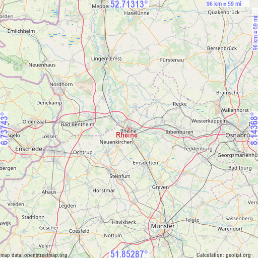
Rheine GPS coordinates[2]
52° 17' 6.324" North, 7° 26' 25.98" East
| Map corner | latitude | longitude |
|---|---|---|
| Upper-left | 52.71313°, | 6.73743° |
| Center: | 52.28509°, | 7.44055° |
| Lower-right: | 51.85287°, | 8.14368° |
| Map W x H: | 95.7×95.6 km | = 59.5×59.4mi |
| max Lat: | 55.01917° ⇑25% North |
| Rheine: | 52.28509° |
| min Lat: | ⇓75% South 47.40724° |
| min Long | Rheine | max Long |
| 5.92978° | 7.44055° | 14.98853° |
| W 11.9%⇐ | ⇒88.1% E |
Elevation
Elevation of Rheine is 41 m = 135 ft, and this is 208.1 m = 683 ft below average elevation for this country.
| Max E: |
1256 m = 4121 ft | 82.3% |
| Avg. | 249.1 m = 817 ft | |
| Rheine | 41 m = 135 ft | |
Min E: |
-5 m = -16 ft | 17.7% |
See also: Rheine elevation on elevation.city.
Geographical zone
Rheine is located in North temperate zone (between Tropic of Cancer and the Arctic Circle). Distance of this North polar circle is 1587.6 km =986.5 mi to North.| Distance of | km | miles | from Rheine |
|---|---|---|---|
| North Pole | 4193.5 | 2605.7 | to North |
| Arctic Circle | 1587.6 | 986.5 | to North |
| Tropic Cancer | 3207.6 | 1993.1 | to South |
| Equator | 5813.6 | 3612.4 | to South |


Nearby cities:
15 places around Rheine: (largest is in red/bold)
• Birgte
14.7 km =9.1 mi,  106°
106°
• Dreierwalde
6.7 km =4.2 mi,  39°
39°
• Emsbüren
15.9 km =9.9 mi,  323°
323°
• Emsdetten
13.8 km =8.6 mi,  154°
154°
• Hopsten
15.3 km =9.5 mi,  45°
45°
• Hörstel
9.8 km =6.1 mi,  81°
81°
• Neuenkirchen
6.5 km =4 mi,  226°
226°
• Ohne
10.9 km =6.8 mi,  259°
259°
• Salzbergen
8.2 km =5.1 mi,  311°
311°
• Samern
12.1 km =7.5 mi,  276°
276°
• Schapen
15.4 km =9.6 mi,  33°
33°
• Schüttorf
15.5 km =9.6 mi,  285°
285°
• Spelle
9.2 km =5.7 mi,  11°
11°
• Suddendorf
14.7 km =9.1 mi, 276°
• Wettringen
11.8 km =7.3 mi,  224°
224°
Sources, notices
• [Note1] Compared only with cities in Germany existing in our database
• [Src1] Map data: © OpenStreetMap contributors (CC-BY-SA)
• [Src2] Other city data from geonames.org with taken over terms of usage.
• [Src3] Geographical zone / Annual Mean Temperature by Robert A. Rohde @ Wikipedia
