Much geodata
Much (North Rhine-Westphalia) is a seat of a fourth-order administrative division; located in Germany in Europe/Berlin (GMT+2) time zone. With population of 15,231 people, there are 1054 cities with bigger population in this country. Compared to other cities in Germany, 56.2% of cities are located further ↓South; 88.5% of cities are located further →East and 50.1% of cities have lower elevation than Much. Note1
Administrative division(s):
- Level 1: North Rhine-Westphalia
- Level 2: Regierungsbezirk Köln
- Level 3: Rhein-Sieg-Kreis
- Level 4: Much


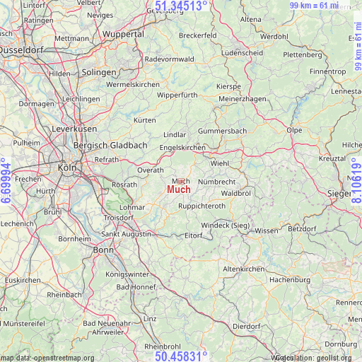
Much GPS coordinates[2]
50° 54' 13.788" North, 7° 24' 11.016" East
| Map corner | latitude | longitude |
|---|---|---|
| Upper-left | 51.34513°, | 6.69994° |
| Center: | 50.90383°, | 7.40306° |
| Lower-right: | 50.45831°, | 8.10619° |
| Map W x H: | 98.6×98.6 km | = 61.3×61.3mi |
| max Lat: | 55.01917° ⇑43.8% North |
| Much: | 50.90383° |
| min Lat: | ⇓56.2% South 47.40724° |
| min Long | Much | max Long |
| 5.92978° | 7.40306° | 14.98853° |
| W 11.5%⇐ | ⇒88.5% E |
Elevation
Elevation of Much is 226 m = 741 ft, and this is 23.1 m = 76 ft below average elevation for this country.
| Max E: |
1256 m = 4121 ft | 49.9% |
| Avg. | 249.1 m = 817 ft | |
| Much | 226 m = 741 ft | |
Min E: |
-5 m = -16 ft | 50.1% |
See also: Germany elevation on elevation.city.
Geographical zone
Much is located in North temperate zone (between Tropic of Cancer and the Arctic Circle). Distance of this North polar circle is 1741.2 km =1081.9 mi to North.| Distance of | km | miles | from Much |
|---|---|---|---|
| North Pole | 4347.1 | 2701.2 | to North |
| Arctic Circle | 1741.2 | 1081.9 | to North |
| Tropic Cancer | 3054.1 | 1897.7 | to South |
| Equator | 5660 | 3517 | to South |


Nearby cities:
15 places around Much: (largest is in red/bold)
• Eitorf
15.6 km =9.7 mi,  167°
167°
• Engelskirchen
9.4 km =5.8 mi,  4°
4°
• Gummersbach
17.7 km =11 mi,  39°
39°
• Hennef
16.6 km =10.3 mi,  210°
210°
• Kürten
18.8 km =11.7 mi,  329°
329°
• Lindlar
13 km =8.1 mi,  352°
352°
• Lohmar
15.1 km =9.4 mi,  241°
241°
• Nümbrecht
9.6 km =6 mi,  89°
89°
• Overath
9 km =5.6 mi,  291°
291°
• Ruppichteroth
8.8 km =5.5 mi,  139°
139°
• Rösrath
15.5 km =9.6 mi,  266°
266°
• Siegburg
17.9 km =11.1 mi,  229°
229°
• Stoßdorf
17.2 km =10.7 mi,  218°
218°
• Waldbröl
15.3 km =9.5 mi,  101°
101°
• Wiehl
11.5 km =7.1 mi,  63°
63°
Sources, notices
• [Note1] Compared only with cities in Germany existing in our database
• [Src1] Map data: © OpenStreetMap contributors (CC-BY-SA)
• [Src2] Other city data from geonames.org with taken over terms of usage.
• [Src3] Geographical zone / Annual Mean Temperature by Robert A. Rohde @ Wikipedia
