Rot an der Rot geodata
Rot an der Rot (Baden-Württemberg) is a seat of a fourth-order administrative division; located in Germany in Europe/Berlin (GMT+2) time zone. In our database, there are 11009 cities with bigger population. Compared to other cities in Germany, 95.4% of cities are located further ↑North; 50.6% of cities are located further ←West and 95.4% of cities have lower elevation than Rot an der Rot. Note1
Administrative division(s):
- Level 1: Baden-Württemberg
- Level 2: Tübingen Region
- Level 3: Landkreis Biberach
- Level 4: Rot an der Rot


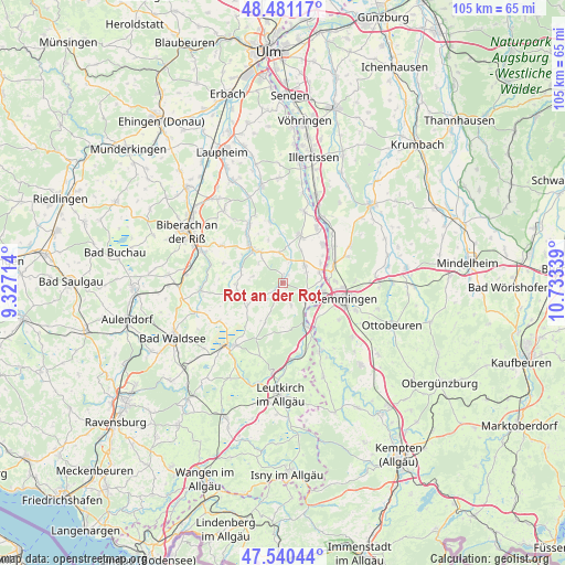
Rot an der Rot GPS coordinates[2]
48° 0' 46.62" North, 10° 1' 48.936" East
| Map corner | latitude | longitude |
|---|---|---|
| Upper-left | 48.48117°, | 9.32714° |
| Center: | 48.01295°, | 10.03026° |
| Lower-right: | 47.54044°, | 10.73339° |
| Map W x H: | 104.6×104.6 km | = 65×65mi |
| max Lat: | 55.01917° ⇑95.4% North |
| Rot an der Rot: | 48.01295° |
| min Lat: | ⇓4.6% South 47.40724° |
| min Long | Rot an der Rot | max Long |
| 5.92978° | 10.03026° | 14.98853° |
| W 50.6%⇐ | ⇒49.4% E |
Elevation
Elevation of Rot an der Rot is 609 m = 1998 ft, and this is 359.9 m = 1181 ft above average elevation for this country.
| Max E: |
1256 m = 4121 ft | 4.6% |
| Rot an der Rot | 609 m 1998 ft | |
| Avg. | 249.1 m = 817 ft | |
Min E: |
-5 m = -16 ft | 95.4% |
See also: Germany elevation on elevation.city.
Geographical zone
Rot an der Rot is located in North temperate zone (between Tropic of Cancer and the Arctic Circle). Distance of this North polar circle is 2062.6 km =1281.6 mi to North.| Distance of | km | miles | from Rot an der Rot |
|---|---|---|---|
| North Pole | 4668.5 | 2900.9 | to North |
| Arctic Circle | 2062.6 | 1281.6 | to North |
| Tropic Cancer | 2732.6 | 1698 | to South |
| Equator | 5338.5 | 3317.2 | to South |


Nearby cities:
15 places around Rot an der Rot: (largest is in red/bold)
• Aitrach
9.7 km =6 mi,  155°
155°
• Amendingen
11.1 km =6.9 mi,  95°
95°
• Berkheim
5.1 km =3.2 mi,  49°
49°
• Buxheim
7.8 km =4.8 mi, 100°
• Dettingen an der Iller
11.6 km =7.2 mi,  33°
33°
• Erlenmoos
7.1 km =4.4 mi,  325°
325°
• Erolzheim
9.1 km =5.7 mi,  20°
20°
• Fellheim
11.2 km =7 mi, 53°
• Heimertingen
9.2 km =5.7 mi,  75°
75°
• Kirchdorf
10.1 km =6.3 mi, 45°
• Memmingen
12 km =7.5 mi,  105°
105°
• Ochsenhausen
8.7 km =5.4 mi,  317°
317°
• Steinhausen an der Rottum
4.7 km =2.9 mi,  274°
274°
• Steinheim
9.7 km =6 mi,  88°
88°
• Tannheim
4.2 km =2.6 mi, 110°
Sources, notices
• [Note1] Compared only with cities in Germany existing in our database
• [Src1] Map data: © OpenStreetMap contributors (CC-BY-SA)
• [Src2] Other city data from geonames.org with taken over terms of usage.
• [Src3] Geographical zone / Annual Mean Temperature by Robert A. Rohde @ Wikipedia
