Ochsenhausen geodata
Ochsenhausen (Baden-Württemberg) is a populated place; located in Germany in Europe/Berlin (GMT+2) time zone. With population of 8,950 people, there are 1802 cities with bigger population in this country. Compared to other cities in Germany, 94.5% of cities are located further ↑North; 50.8% of cities are located further →East and 94.2% of cities have lower elevation than Ochsenhausen. Note1
Administrative division(s):
- Level 1: Baden-Württemberg
- Level 2: Tübingen Region
- Level 3: Landkreis Biberach
- Level 4: Ochsenhausen


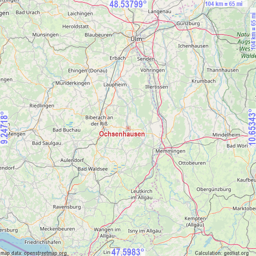
Ochsenhausen GPS coordinates[2]
48° 4' 13.044" North, 9° 57' 1.08" East
| Map corner | latitude | longitude |
|---|---|---|
| Upper-left | 48.53799°, | 9.24718° |
| Center: | 48.07029°, | 9.9503° |
| Lower-right: | 47.5983°, | 10.65343° |
| Map W x H: | 104.5×104.5 km | = 64.9×64.9mi |
| max Lat: | 55.01917° ⇑94.5% North |
| Ochsenhausen: | 48.07029° |
| min Lat: | ⇓5.5% South 47.40724° |
| min Long | Ochsenhausen | max Long |
| 5.92978° | 9.9503° | 14.98853° |
| W 49.2%⇐ | ⇒50.8% E |
Elevation
Elevation of Ochsenhausen is 579 m = 1900 ft, and this is 329.9 m = 1082 ft above average elevation for this country.
| Max E: |
1256 m = 4121 ft | 5.8% |
| Ochsenhausen | 579 m 1900 ft | |
| Avg. | 249.1 m = 817 ft | |
Min E: |
-5 m = -16 ft | 94.2% |
See also: Germany elevation on elevation.city.
Geographical zone
Ochsenhausen is located in North temperate zone (between Tropic of Cancer and the Arctic Circle). Distance of this North polar circle is 2056.3 km =1277.7 mi to North.| Distance of | km | miles | from Ochsenhausen |
|---|---|---|---|
| North Pole | 4662.1 | 2896.9 | to North |
| Arctic Circle | 2056.3 | 1277.7 | to North |
| Tropic Cancer | 2739 | 1701.9 | to South |
| Equator | 5344.9 | 3321.2 | to South |


Nearby cities:
15 places around Ochsenhausen: (largest is in red/bold)
• Berkheim
10.3 km =6.4 mi,  107°
107°
• Biberach an der Riß
12.1 km =7.5 mi,  282°
282°
• Dettingen an der Iller
12.8 km =8 mi,  75°
75°
• Eberhardzell
12.6 km =7.8 mi,  231°
231°
• Erlenmoos
2 km =1.2 mi, 106°
• Erolzheim
9.4 km =5.8 mi, 76°
• Gutenzell-Hürbel
5.7 km =3.5 mi,  25°
25°
• Kirchberg an der Iller
12.1 km =7.5 mi,  54°
54°
• Kirchdorf
13.1 km =8.1 mi,  86°
86°
• Maselheim
8.6 km =5.3 mi,  324°
324°
• Rot an der Rot
8.7 km =5.4 mi,  137°
137°
• Schwendi
11.7 km =7.3 mi,  9°
9°
• Steinhausen an der Rottum
6.1 km =3.8 mi,  168°
168°
• Tannheim
12.6 km =7.8 mi,  128°
128°
• Ummendorf
8.7 km =5.4 mi,  267°
267°
Sources, notices
• [Note1] Compared only with cities in Germany existing in our database
• [Src1] Map data: © OpenStreetMap contributors (CC-BY-SA)
• [Src2] Other city data from geonames.org with taken over terms of usage.
• [Src3] Geographical zone / Annual Mean Temperature by Robert A. Rohde @ Wikipedia
