Erlenmoos geodata
Erlenmoos (Baden-Württemberg) is a seat of a fourth-order administrative division; located in Germany in Europe/Berlin (GMT+2) time zone. With population of 1,650 people, there are 5602 cities with bigger population in this country. Compared to other cities in Germany, 94.6% of cities are located further ↑North; 50.4% of cities are located further →East and 96.4% of cities have lower elevation than Erlenmoos. Note1
Administrative division(s):
- Level 1: Baden-Württemberg
- Level 2: Tübingen Region
- Level 3: Landkreis Biberach
- Level 4: Erlenmoos


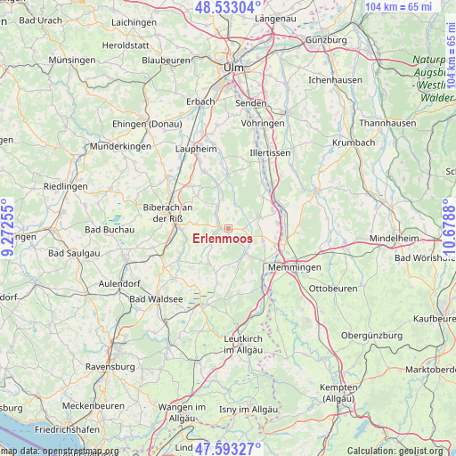
Erlenmoos GPS coordinates[2]
48° 3' 55.08" North, 9° 58' 32.412" East
| Map corner | latitude | longitude |
|---|---|---|
| Upper-left | 48.53304°, | 9.27255° |
| Center: | 48.0653°, | 9.97567° |
| Lower-right: | 47.59327°, | 10.6788° |
| Map W x H: | 104.5×104.5 km | = 64.9×64.9mi |
| max Lat: | 55.01917° ⇑94.6% North |
| Erlenmoos: | 48.0653° |
| min Lat: | ⇓5.4% South 47.40724° |
| min Long | Erlenmoos | max Long |
| 5.92978° | 9.97567° | 14.98853° |
| W 49.6%⇐ | ⇒50.4% E |
Elevation
Elevation of Erlenmoos is 639 m = 2096 ft, and this is 389.9 m = 1279 ft above average elevation for this country.
| Max E: |
1256 m = 4121 ft | 3.6% |
| Erlenmoos | 639 m 2096 ft | |
| Avg. | 249.1 m = 817 ft | |
Min E: |
-5 m = -16 ft | 96.4% |
See also: Germany elevation on elevation.city.
Geographical zone
Erlenmoos is located in North temperate zone (between Tropic of Cancer and the Arctic Circle). Distance of this North polar circle is 2056.8 km =1278 mi to North.| Distance of | km | miles | from Erlenmoos |
|---|---|---|---|
| North Pole | 4662.7 | 2897.3 | to North |
| Arctic Circle | 2056.8 | 1278 | to North |
| Tropic Cancer | 2738.4 | 1701.6 | to South |
| Equator | 5344.4 | 3320.9 | to South |


Nearby cities:
15 places around Erlenmoos: (largest is in red/bold)
• Berkheim
8.3 km =5.2 mi,  107°
107°
• Dettingen an der Iller
11.2 km =7 mi,  69°
69°
• Erolzheim
7.7 km =4.8 mi, 69°
• Fellheim
13.1 km =8.1 mi,  86°
86°
• Gutenzell-Hürbel
5.7 km =3.5 mi,  5°
5°
• Kellmünz
12.9 km =8 mi,  61°
61°
• Kirchberg an der Iller
11 km =6.8 mi,  46°
46°
• Kirchdorf
11.3 km =7 mi,  83°
83°
• Maselheim
10.2 km =6.3 mi,  317°
317°
• Ochsenhausen
2 km =1.2 mi,  286°
286°
• Rot an der Rot
7.1 km =4.4 mi,  145°
145°
• Schwendi
12.1 km =7.5 mi,  359°
359°
• Steinhausen an der Rottum
5.4 km =3.4 mi,  187°
187°
• Tannheim
10.8 km =6.7 mi,  132°
132°
• Ummendorf
10.6 km =6.6 mi,  270°
270°
Sources, notices
• [Note1] Compared only with cities in Germany existing in our database
• [Src1] Map data: © OpenStreetMap contributors (CC-BY-SA)
• [Src2] Other city data from geonames.org with taken over terms of usage.
• [Src3] Geographical zone / Annual Mean Temperature by Robert A. Rohde @ Wikipedia
