Roschbach geodata
Roschbach (Rheinland-Pfalz) is a seat of a fourth-order administrative division; located in Germany in Europe/Berlin (GMT+2) time zone. With population of 841 people, there are 7739 cities with bigger population in this country. Compared to other cities in Germany, 79.7% of cities are located further ↑North; 75.1% of cities are located further →East and 58% of cities have higher elevation than Roschbach. Note1
Administrative division(s):
- Level 1: Rheinland-Pfalz
- Level 3: Landkreis Südliche Weinstraße
- Level 4: Roschbach


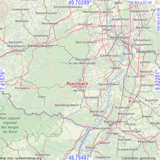
Roschbach GPS coordinates[2]
49° 14' 45.996" North, 8° 7' 8.004" East
| Map corner | latitude | longitude |
|---|---|---|
| Upper-left | 49.70299°, | 7.41576° |
| Center: | 49.24611°, | 8.11889° |
| Lower-right: | 48.78497°, | 8.82201° |
| Map W x H: | 102.1×102.1 km | = 63.4×63.4mi |
| max Lat: | 55.01917° ⇑79.7% North |
| Roschbach: | 49.24611° |
| min Lat: | ⇓20.3% South 47.40724° |
| min Long | Roschbach | max Long |
| 5.92978° | 8.11889° | 14.98853° |
| W 24.9%⇐ | ⇒75.1% E |
Elevation
Elevation of Roschbach is 168 m = 551 ft, and this is 81.1 m = 266 ft below average elevation for this country.
| Max E: |
1256 m = 4121 ft | 58% |
| Avg. | 249.1 m = 817 ft | |
| Roschbach | 168 m = 551 ft | |
Min E: |
-5 m = -16 ft | 42% |
See also: Germany elevation on elevation.city.
Geographical zone
Roschbach is located in North temperate zone (between Tropic of Cancer and the Arctic Circle). Distance of this North polar circle is 1925.5 km =1196.4 mi to North.| Distance of | km | miles | from Roschbach |
|---|---|---|---|
| North Pole | 4531.4 | 2815.7 | to North |
| Arctic Circle | 1925.5 | 1196.4 | to North |
| Tropic Cancer | 2869.7 | 1783.1 | to South |
| Equator | 5475.7 | 3402.4 | to South |


Nearby cities:
15 places around Roschbach: (largest is in red/bold)
• Bornheim
4.2 km =2.6 mi,  129°
129°
• Burrweiler
2.9 km =1.8 mi,  273°
273°
• Böchingen
2.1 km =1.3 mi,  241°
241°
• Edenkoben
4.2 km =2.6 mi,  8°
8°
• Edesheim
2.2 km =1.4 mi,  31°
31°
• Essingen
4.2 km =2.6 mi,  105°
105°
• Flemlingen
1.8 km =1.1 mi,  257°
257°
• Frankweiler
4.9 km =3 mi,  245°
245°
• Gleisweiler
3.6 km =2.2 mi, 263°
• Großfischlingen
4.9 km =3 mi,  58°
58°
• Hainfeld
1.8 km =1.1 mi,  314°
314°
• Knöringen
2.1 km =1.3 mi,  116°
116°
• Rhodt unter Rietburg
2.7 km =1.7 mi,  342°
342°
• Walsheim
1.1 km =0.7 mi,  149°
149°
• Weyher
3.4 km =2.1 mi, 314°
Sources, notices
• [Note1] Compared only with cities in Germany existing in our database
• [Src1] Map data: © OpenStreetMap contributors (CC-BY-SA)
• [Src2] Other city data from geonames.org with taken over terms of usage.
• [Src3] Geographical zone / Annual Mean Temperature by Robert A. Rohde @ Wikipedia
