Knöringen geodata
Knöringen (Rheinland-Pfalz) is a seat of a fourth-order administrative division; located in Germany in Europe/Berlin (GMT+2) time zone. With population of 488 people, there are 9425 cities with bigger population in this country. Compared to other cities in Germany, 79.8% of cities are located further ↑North; 74.8% of cities are located further →East and 59.4% of cities have higher elevation than Knöringen. Note1
Administrative division(s):
- Level 1: Rheinland-Pfalz
- Level 3: Landkreis Südliche Weinstraße
- Level 4: Knöringen


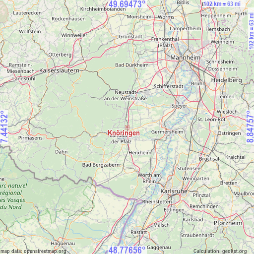
Knöringen GPS coordinates[2]
49° 14' 16.008" North, 8° 8' 39.984" East
| Map corner | latitude | longitude |
|---|---|---|
| Upper-left | 49.69473°, | 7.44132° |
| Center: | 49.23778°, | 8.14444° |
| Lower-right: | 48.77656°, | 8.84757° |
| Map W x H: | 102.1×102.1 km | = 63.4×63.4mi |
| max Lat: | 55.01917° ⇑79.8% North |
| Knöringen: | 49.23778° |
| min Lat: | ⇓20.2% South 47.40724° |
| min Long | Knöringen | max Long |
| 5.92978° | 8.14444° | 14.98853° |
| W 25.2%⇐ | ⇒74.8% E |
Elevation
Elevation of Knöringen is 157 m = 515 ft, and this is 92.1 m = 302 ft below average elevation for this country.
| Max E: |
1256 m = 4121 ft | 59.4% |
| Avg. | 249.1 m = 817 ft | |
| Knöringen | 157 m = 515 ft | |
Min E: |
-5 m = -16 ft | 40.6% |
See also: Germany elevation on elevation.city.
Geographical zone
Knöringen is located in North temperate zone (between Tropic of Cancer and the Arctic Circle). Distance of this North polar circle is 1926.4 km =1197 mi to North.| Distance of | km | miles | from Knöringen |
|---|---|---|---|
| North Pole | 4532.3 | 2816.2 | to North |
| Arctic Circle | 1926.4 | 1197 | to North |
| Tropic Cancer | 2868.8 | 1782.6 | to South |
| Equator | 5474.7 | 3401.8 | to South |


Nearby cities:
15 places around Knöringen: (largest is in red/bold)
• Bornheim
2.2 km =1.4 mi,  141°
141°
• Burrweiler
4.9 km =3 mi,  283°
283°
• Böchingen
3.7 km =2.3 mi,  268°
268°
• Edesheim
2.9 km =1.8 mi,  346°
346°
• Essingen
2.2 km =1.4 mi,  95°
95°
• Flemlingen
3.6 km =2.2 mi, 278°
• Großfischlingen
4.2 km =2.6 mi,  33°
33°
• Hainfeld
3.8 km =2.4 mi,  304°
304°
• Hochstadt
4.8 km =3 mi,  76°
76°
• Kleinfischlingen
4.2 km =2.6 mi,  47°
47°
• Landau in der Pfalz
4.8 km =3 mi,  204°
204°
• Rhodt unter Rietburg
4.4 km =2.7 mi,  323°
323°
• Roschbach
2.1 km =1.3 mi, 296°
• Venningen
5.3 km =3.3 mi,  23°
23°
• Walsheim
1.3 km =0.8 mi, 267°
Sources, notices
• [Note1] Compared only with cities in Germany existing in our database
• [Src1] Map data: © OpenStreetMap contributors (CC-BY-SA)
• [Src2] Other city data from geonames.org with taken over terms of usage.
• [Src3] Geographical zone / Annual Mean Temperature by Robert A. Rohde @ Wikipedia
