Edenkoben geodata
Edenkoben (Rheinland-Pfalz) is a populated place; located in Germany in Europe/Berlin (GMT+2) time zone. With population of 6,668 people, there are 2263 cities with bigger population in this country. Compared to other cities in Germany, 78.9% of cities are located further ↑North; 75% of cities are located further →East and 57.5% of cities have higher elevation than Edenkoben. Note1
Administrative division(s):
- Level 1: Rheinland-Pfalz
- Level 3: Landkreis Südliche Weinstraße
- Level 4: Edenkoben


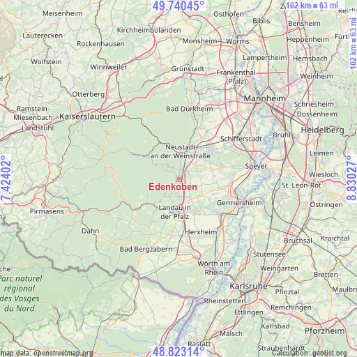
Edenkoben GPS coordinates[2]
49° 17' 2.148" North, 8° 7' 37.704" East
| Map corner | latitude | longitude |
|---|---|---|
| Upper-left | 49.74045°, | 7.42402° |
| Center: | 49.28393°, | 8.12714° |
| Lower-right: | 48.82314°, | 8.83027° |
| Map W x H: | 102×102 km | = 63.4×63.4mi |
| max Lat: | 55.01917° ⇑78.9% North |
| Edenkoben: | 49.28393° |
| min Lat: | ⇓21.1% South 47.40724° |
| min Long | Edenkoben | max Long |
| 5.92978° | 8.12714° | 14.98853° |
| W 25%⇐ | ⇒75% E |
Elevation
Elevation of Edenkoben is 171 m = 561 ft, and this is 78.1 m = 256 ft below average elevation for this country.
| Max E: |
1256 m = 4121 ft | 57.5% |
| Avg. | 249.1 m = 817 ft | |
| Edenkoben | 171 m = 561 ft | |
Min E: |
-5 m = -16 ft | 42.5% |
See also: Germany elevation on elevation.city.
Geographical zone
Edenkoben is located in North temperate zone (between Tropic of Cancer and the Arctic Circle). Distance of this North polar circle is 1921.3 km =1193.8 mi to North.| Distance of | km | miles | from Edenkoben |
|---|---|---|---|
| North Pole | 4527.2 | 2813.1 | to North |
| Arctic Circle | 1921.3 | 1193.8 | to North |
| Tropic Cancer | 2873.9 | 1785.8 | to South |
| Equator | 5479.9 | 3405.1 | to South |


Nearby cities:
15 places around Edenkoben: (largest is in red/bold)
• Burrweiler
5.4 km =3.4 mi,  221°
221°
• Edesheim
2.4 km =1.5 mi,  166°
166°
• Flemlingen
5.1 km =3.2 mi,  207°
207°
• Großfischlingen
3.9 km =2.4 mi,  115°
115°
• Hainfeld
3.5 km =2.2 mi, 212°
• Kirrweiler
3.2 km =2 mi,  53°
53°
• Kleinfischlingen
4.9 km =3 mi, 117°
• Knöringen
5.3 km =3.3 mi, 166°
• Maikammer
2.4 km =1.5 mi,  7°
7°
• Rhodt unter Rietburg
2.1 km =1.3 mi, 221°
• Roschbach
4.2 km =2.6 mi,  188°
188°
• Sankt Martin
2.4 km =1.5 mi,  318°
318°
• Venningen
3.4 km =2.1 mi,  94°
94°
• Walsheim
5.2 km =3.2 mi,  180°
180°
• Weyher
3.5 km =2.2 mi,  239°
239°
Sources, notices
• [Note1] Compared only with cities in Germany existing in our database
• [Src1] Map data: © OpenStreetMap contributors (CC-BY-SA)
• [Src2] Other city data from geonames.org with taken over terms of usage.
• [Src3] Geographical zone / Annual Mean Temperature by Robert A. Rohde @ Wikipedia
