Rommelsried geodata
Rommelsried (Bavaria) is a populated place; located in Germany in Europe/Berlin (GMT+2) time zone. With population of 650 people, there are 8557 cities with bigger population in this country. Compared to other cities in Germany, 90.5% of cities are located further ↑North; 62.6% of cities are located further ←West and 87.3% of cities have lower elevation than Rommelsried. Note1
Administrative division(s):
- Level 1: Bavaria
- Level 2: Swabia
- Level 3: Landkreis Augsburg
- Level 4: Kutzenhausen


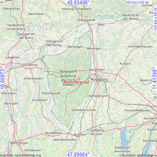
Rommelsried GPS coordinates[2]
48° 22' 8.724" North, 10° 42' 46.26" East
| Map corner | latitude | longitude |
|---|---|---|
| Upper-left | 48.83406°, | 10.00973° |
| Center: | 48.36909°, | 10.71285° |
| Lower-right: | 47.89984°, | 11.41598° |
| Map W x H: | 103.9×103.9 km | = 64.6×64.6mi |
| max Lat: | 55.01917° ⇑90.5% North |
| Rommelsried: | 48.36909° |
| min Lat: | ⇓9.5% South 47.40724° |
| min Long | Rommelsried | max Long |
| 5.92978° | 10.71285° | 14.98853° |
| W 62.6%⇐ | ⇒37.4% E |
Elevation
Elevation of Rommelsried is 488 m = 1601 ft, and this is 238.9 m = 784 ft above average elevation for this country.
| Max E: |
1256 m = 4121 ft | 12.7% |
| Rommelsried | 488 m 1601 ft | |
| Avg. | 249.1 m = 817 ft | |
Min E: |
-5 m = -16 ft | 87.3% |
See also: Germany elevation on elevation.city.
Geographical zone
Rommelsried is located in North temperate zone (between Tropic of Cancer and the Arctic Circle). Distance of this North polar circle is 2023 km =1257 mi to North.| Distance of | km | miles | from Rommelsried |
|---|---|---|---|
| North Pole | 4628.9 | 2876.3 | to North |
| Arctic Circle | 2023 | 1257 | to North |
| Tropic Cancer | 2772.2 | 1722.6 | to South |
| Equator | 5378.1 | 3341.8 | to South |


Nearby cities:
15 places around Rommelsried: (largest is in red/bold)
• Adelsried
6.2 km =3.9 mi,  3°
3°
• Aystetten
6.3 km =3.9 mi,  49°
49°
• Bonstetten
7.9 km =4.9 mi,  355°
355°
• Diedorf
5.4 km =3.4 mi,  109°
109°
• Dinkelscherben
9.4 km =5.8 mi,  255°
255°
• Fischach
9.7 km =6 mi,  205°
205°
• Gablingen
11.8 km =7.3 mi,  40°
40°
• Gessertshausen
4.7 km =2.9 mi,  161°
161°
• Heretsried
10.2 km =6.3 mi,  9°
9°
• Horgau
3.6 km =2.2 mi,  322°
322°
• Kutzenhausen
3.3 km =2.1 mi,  204°
204°
• Stadtbergen
9.9 km =6.2 mi,  91°
91°
• Ustersbach
7.5 km =4.7 mi,  218°
218°
• Welden
10.3 km =6.4 mi,  338°
338°
• Zusmarshausen
9.1 km =5.7 mi,  292°
292°
Sources, notices
• [Note1] Compared only with cities in Germany existing in our database
• [Src1] Map data: © OpenStreetMap contributors (CC-BY-SA)
• [Src2] Other city data from geonames.org with taken over terms of usage.
• [Src3] Geographical zone / Annual Mean Temperature by Robert A. Rohde @ Wikipedia
