Dinkelscherben geodata
Dinkelscherben (Bavaria) is a populated place; located in Germany in Europe/Berlin (GMT+2) time zone. With population of 6,742 people, there are 2248 cities with bigger population in this country. Compared to other cities in Germany, 90.7% of cities are located further ↑North; 60.5% of cities are located further ←West and 84.5% of cities have lower elevation than Dinkelscherben. Note1
Administrative division(s):
- Level 1: Bavaria
- Level 2: Swabia
- Level 3: Landkreis Augsburg
- Level 4: Dinkelscherben, Markt


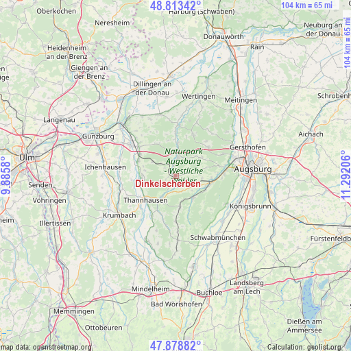
Dinkelscherben GPS coordinates[2]
48° 20' 53.736" North, 10° 35' 20.148" East
| Map corner | latitude | longitude |
|---|---|---|
| Upper-left | 48.81342°, | 9.8858° |
| Center: | 48.34826°, | 10.58893° |
| Lower-right: | 47.87882°, | 11.29206° |
| Map W x H: | 103.9×103.9 km | = 64.6×64.6mi |
| max Lat: | 55.01917° ⇑90.7% North |
| Dinkelscherben: | 48.34826° |
| min Lat: | ⇓9.3% South 47.40724° |
| min Long | Dinkelscherben | max Long |
| 5.92978° | 10.58893° | 14.98853° |
| W 60.5%⇐ | ⇒39.5% E |
Elevation
Elevation of Dinkelscherben is 465 m = 1526 ft, and this is 215.9 m = 708 ft above average elevation for this country.
| Max E: |
1256 m = 4121 ft | 15.5% |
| Dinkelscherben | 465 m 1526 ft | |
| Avg. | 249.1 m = 817 ft | |
Min E: |
-5 m = -16 ft | 84.5% |
See also: Germany elevation on elevation.city.
Geographical zone
Dinkelscherben is located in North temperate zone (between Tropic of Cancer and the Arctic Circle). Distance of this North polar circle is 2025.4 km =1258.5 mi to North.| Distance of | km | miles | from Dinkelscherben |
|---|---|---|---|
| North Pole | 4631.2 | 2877.7 | to North |
| Arctic Circle | 2025.4 | 1258.5 | to North |
| Tropic Cancer | 2769.9 | 1721.1 | to South |
| Equator | 5375.8 | 3340.4 | to South |


Nearby cities:
15 places around Dinkelscherben: (largest is in red/bold)
• Burtenbach
10.1 km =6.3 mi,  265°
265°
• Fischach
8.1 km =5 mi,  142°
142°
• Gessertshausen
10.8 km =6.7 mi,  101°
101°
• Horgau
8.7 km =5.4 mi,  53°
53°
• Jettingen-Scheppach
12.1 km =7.5 mi,  292°
292°
• Kutzenhausen
7.8 km =4.8 mi, 95°
• Landensberg
10.7 km =6.6 mi,  333°
333°
• Langenneufnach
9.1 km =5.7 mi,  174°
174°
• Mickhausen
12.4 km =7.7 mi,  162°
162°
• Münsterhausen
10.8 km =6.7 mi,  246°
246°
• Rommelsried
9.4 km =5.8 mi,  75°
75°
• Thannhausen
11.4 km =7.1 mi,  230°
230°
• Ustersbach
5.7 km =3.5 mi,  127°
127°
• Ziemetshausen
7.4 km =4.6 mi,  212°
212°
• Zusmarshausen
5.8 km =3.6 mi,  7°
7°
Sources, notices
• [Note1] Compared only with cities in Germany existing in our database
• [Src1] Map data: © OpenStreetMap contributors (CC-BY-SA)
• [Src2] Other city data from geonames.org with taken over terms of usage.
• [Src3] Geographical zone / Annual Mean Temperature by Robert A. Rohde @ Wikipedia
