Horgau geodata
Horgau (Bavaria) is a seat of a fourth-order administrative division; located in Germany in Europe/Berlin (GMT+2) time zone. With population of 2,459 people, there are 4486 cities with bigger population in this country. Compared to other cities in Germany, 90.3% of cities are located further ↑North; 62.1% of cities are located further ←West and 84.7% of cities have lower elevation than Horgau. Note1
Administrative division(s):
- Level 1: Bavaria
- Level 2: Swabia
- Level 3: Landkreis Augsburg
- Level 4: Horgau


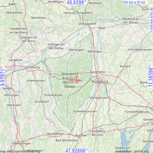
Horgau GPS coordinates[2]
48° 23' 42.252" North, 10° 40' 58.188" East
| Map corner | latitude | longitude |
|---|---|---|
| Upper-left | 48.8598°, | 9.97971° |
| Center: | 48.39507°, | 10.68283° |
| Lower-right: | 47.92606°, | 11.38596° |
| Map W x H: | 103.8×103.8 km | = 64.5×64.5mi |
| max Lat: | 55.01917° ⇑90.3% North |
| Horgau: | 48.39507° |
| min Lat: | ⇓9.7% South 47.40724° |
| min Long | Horgau | max Long |
| 5.92978° | 10.68283° | 14.98853° |
| W 62.1%⇐ | ⇒37.9% E |
Elevation
Elevation of Horgau is 466 m = 1529 ft, and this is 216.9 m = 712 ft above average elevation for this country.
| Max E: |
1256 m = 4121 ft | 15.3% |
| Horgau | 466 m 1529 ft | |
| Avg. | 249.1 m = 817 ft | |
Min E: |
-5 m = -16 ft | 84.7% |
See also: Germany elevation on elevation.city.
Geographical zone
Horgau is located in North temperate zone (between Tropic of Cancer and the Arctic Circle). Distance of this North polar circle is 2020.1 km =1255.2 mi to North.| Distance of | km | miles | from Horgau |
|---|---|---|---|
| North Pole | 4626 | 2874.5 | to North |
| Arctic Circle | 2020.1 | 1255.2 | to North |
| Tropic Cancer | 2775.1 | 1724.4 | to South |
| Equator | 5381 | 3343.6 | to South |


Nearby cities:
15 places around Horgau: (largest is in red/bold)
• Adelsried
4.2 km =2.6 mi,  38°
38°
• Altenmünster
10.3 km =6.4 mi,  318°
318°
• Aystetten
7.1 km =4.4 mi,  80°
80°
• Bonstetten
5.3 km =3.3 mi,  18°
18°
• Diedorf
8.7 km =5.4 mi,  122°
122°
• Dinkelscherben
8.7 km =5.4 mi,  233°
233°
• Emersacker
10.5 km =6.5 mi,  356°
356°
• Gablingen
11.6 km =7.2 mi,  58°
58°
• Gessertshausen
8.2 km =5.1 mi,  153°
153°
• Heretsried
8.2 km =5.1 mi,  28°
28°
• Kutzenhausen
6 km =3.7 mi,  171°
171°
• Rommelsried
3.6 km =2.2 mi,  142°
142°
• Ustersbach
9 km =5.6 mi,  195°
195°
• Welden
6.9 km =4.3 mi,  346°
346°
• Zusmarshausen
6.2 km =3.9 mi,  275°
275°
Sources, notices
• [Note1] Compared only with cities in Germany existing in our database
• [Src1] Map data: © OpenStreetMap contributors (CC-BY-SA)
• [Src2] Other city data from geonames.org with taken over terms of usage.
• [Src3] Geographical zone / Annual Mean Temperature by Robert A. Rohde @ Wikipedia
