Röhrnbach geodata
Röhrnbach (Bavaria) is a seat of a fourth-order administrative division; located in Germany in Europe/Berlin (GMT+2) time zone. With population of 4,579 people, there are 2996 cities with bigger population in this country. Compared to other cities in Germany, 86% of cities are located further ↑North; 95.9% of cities are located further ←West and 79.9% of cities have lower elevation than Röhrnbach. Note1
Administrative division(s):
- Level 1: Bavaria
- Level 2: Lower Bavaria
- Level 3: Landkreis Freyung-Grafenau
- Level 4: Röhrnbach, Markt


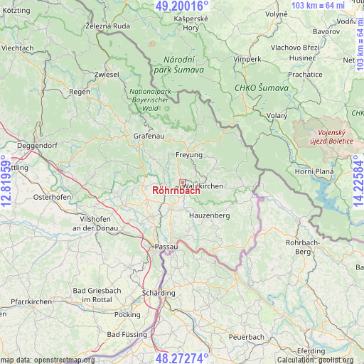
Röhrnbach GPS coordinates[2]
48° 44' 18.924" North, 13° 31' 21.756" East
| Map corner | latitude | longitude |
|---|---|---|
| Upper-left | 49.20016°, | 12.81959° |
| Center: | 48.73859°, | 13.52271° |
| Lower-right: | 48.27274°, | 14.22584° |
| Map W x H: | 103.1×103.1 km | = 64.1×64.1mi |
| max Lat: | 55.01917° ⇑86% North |
| Röhrnbach: | 48.73859° |
| min Lat: | ⇓14% South 47.40724° |
| min Long | Röhrnbach | max Long |
| 5.92978° | 13.52271° | 14.98853° |
| W 95.9%⇐ | ⇒4.1% E |
Elevation
Elevation of Röhrnbach is 432 m = 1417 ft, and this is 182.9 m = 600 ft above average elevation for this country.
| Max E: |
1256 m = 4121 ft | 20.1% |
| Röhrnbach | 432 m 1417 ft | |
| Avg. | 249.1 m = 817 ft | |
Min E: |
-5 m = -16 ft | 79.9% |
See also: Germany elevation on elevation.city.
Geographical zone
Röhrnbach is located in North temperate zone (between Tropic of Cancer and the Arctic Circle). Distance of this North polar circle is 1982 km =1231.6 mi to North.| Distance of | km | miles | from Röhrnbach |
|---|---|---|---|
| North Pole | 4587.8 | 2850.7 | to North |
| Arctic Circle | 1982 | 1231.6 | to North |
| Tropic Cancer | 2813.3 | 1748.1 | to South |
| Equator | 5419.2 | 3367.3 | to South |


Nearby cities:
15 places around Röhrnbach: (largest is in red/bold)
• Büchlberg
7.5 km =4.7 mi,  180°
180°
• Freyung
8.1 km =5 mi,  13°
13°
• Fürsteneck
4.8 km =3 mi,  239°
239°
• Grainet
11.6 km =7.2 mi,  53°
53°
• Hauzenberg
12.5 km =7.8 mi,  142°
142°
• Hinterschmiding
11.1 km =6.9 mi,  32°
32°
• Hohenau
12.6 km =7.8 mi,  348°
348°
• Hutthurm
8.2 km =5.1 mi,  207°
207°
• Neukirchen vorm Wald
11.9 km =7.4 mi, 239°
• Perlesreut
7.8 km =4.8 mi,  307°
307°
• Ringelai
9.1 km =5.7 mi,  335°
335°
• Ruderting
12.6 km =7.8 mi,  218°
218°
• Tittling
10.4 km =6.5 mi,  262°
262°
• Waldkirchen
5.8 km =3.6 mi,  96°
96°
• Witzmannsberg
8.2 km =5.1 mi,  252°
252°
Sources, notices
• [Note1] Compared only with cities in Germany existing in our database
• [Src1] Map data: © OpenStreetMap contributors (CC-BY-SA)
• [Src2] Other city data from geonames.org with taken over terms of usage.
• [Src3] Geographical zone / Annual Mean Temperature by Robert A. Rohde @ Wikipedia
