Rhinow geodata
Rhinow (Brandenburg) is a populated place; located in Germany in Europe/Berlin (GMT+2) time zone. With population of 1,923 people, there are 5177 cities with bigger population in this country. Compared to other cities in Germany, 80.1% of cities are located further ↓South; 86.2% of cities are located further ←West and 87% of cities have higher elevation than Rhinow. Note1


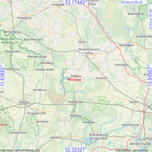
Rhinow GPS coordinates[2]
52° 45' 3.384" North, 12° 20' 30.984" East
| Map corner | latitude | longitude |
|---|---|---|
| Upper-left | 53.17445°, | 11.63882° |
| Center: | 52.75094°, | 12.34194° |
| Lower-right: | 52.32327°, | 13.04507° |
| Map W x H: | 94.6×94.6 km | = 58.8×58.8mi |
| max Lat: | 55.01917° ⇑19.9% North |
| Rhinow: | 52.75094° |
| min Lat: | ⇓80.1% South 47.40724° |
| min Long | Rhinow | max Long |
| 5.92978° | 12.34194° | 14.98853° |
| W 86.2%⇐ | ⇒13.8% E |
Elevation
Elevation of Rhinow is 30 m = 98 ft, and this is 219.1 m = 719 ft below average elevation for this country.
| Max E: |
1256 m = 4121 ft | 87% |
| Avg. | 249.1 m = 817 ft | |
| Rhinow | 30 m = 98 ft | |
Min E: |
-5 m = -16 ft | 13% |
See also: Germany elevation on elevation.city.
Geographical zone
Rhinow is located in North temperate zone (between Tropic of Cancer and the Arctic Circle). Distance of this North polar circle is 1535.8 km =954.3 mi to North.| Distance of | km | miles | from Rhinow |
|---|---|---|---|
| North Pole | 4141.7 | 2573.5 | to North |
| Arctic Circle | 1535.8 | 954.3 | to North |
| Tropic Cancer | 3259.4 | 2025.3 | to South |
| Equator | 5865.4 | 3644.6 | to South |


Nearby cities:
15 places around Rhinow: (largest is in red/bold)
• Arneburg
24.2 km =15 mi,  249°
249°
• Breddin
17 km =10.6 mi,  332°
332°
• Dreetz
9.8 km =6.1 mi,  53°
53°
• Friesack
16.1 km =10 mi,  95°
95°
• Großderschau
4.7 km =2.9 mi,  21°
21°
• Havelberg
20 km =12.4 mi,  296°
296°
• Kamern
15.4 km =9.6 mi,  268°
268°
• Klietz
20.6 km =12.8 mi,  243°
243°
• Kotzen
17.6 km =10.9 mi,  137°
137°
• Kyritz
21.6 km =13.4 mi,  9°
9°
• Nennhausen
19.9 km =12.4 mi,  147°
147°
• Rathenow
16.1 km =10 mi,  181°
181°
• Sandau
20.4 km =12.7 mi,  282°
282°
• Schollene
11.7 km =7.3 mi,  225°
225°
• Wusterhausen
17.5 km =10.9 mi,  27°
27°
Sources, notices
• [Note1] Compared only with cities in Germany existing in our database
• [Src1] Map data: © OpenStreetMap contributors (CC-BY-SA)
• [Src2] Other city data from geonames.org with taken over terms of usage.
• [Src3] Geographical zone / Annual Mean Temperature by Robert A. Rohde @ Wikipedia
