Schollene geodata
Schollene (Saxony-Anhalt) is a seat of a fourth-order administrative division; located in Germany in Europe/Berlin (GMT+2) time zone. In our database, there are 11009 cities with bigger population. Compared to other cities in Germany, 79.4% of cities are located further ↓South; 84.9% of cities are located further ←West and 85.4% of cities have higher elevation than Schollene. Note1


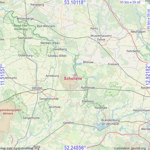
Schollene GPS coordinates[2]
52° 40' 37.02" North, 12° 13' 7.284" East
| Map corner | latitude | longitude |
|---|---|---|
| Upper-left | 53.10118°, | 11.51557° |
| Center: | 52.67695°, | 12.21869° |
| Lower-right: | 52.24856°, | 12.92182° |
| Map W x H: | 94.8×94.8 km | = 58.9×58.9mi |
| max Lat: | 55.01917° ⇑20.6% North |
| Schollene: | 52.67695° |
| min Lat: | ⇓79.4% South 47.40724° |
| min Long | Schollene | max Long |
| 5.92978° | 12.21869° | 14.98853° |
| W 84.9%⇐ | ⇒15.1% E |
Elevation
Elevation of Schollene is 34 m = 112 ft, and this is 215.1 m = 706 ft below average elevation for this country.
| Max E: |
1256 m = 4121 ft | 85.4% |
| Avg. | 249.1 m = 817 ft | |
| Schollene | 34 m = 112 ft | |
Min E: |
-5 m = -16 ft | 14.6% |
See also: Germany elevation on elevation.city.
Geographical zone
Schollene is located in North temperate zone (between Tropic of Cancer and the Arctic Circle). Distance of this North polar circle is 1544 km =959.4 mi to North.| Distance of | km | miles | from Schollene |
|---|---|---|---|
| North Pole | 4149.9 | 2578.6 | to North |
| Arctic Circle | 1544 | 959.4 | to North |
| Tropic Cancer | 3251.2 | 2020.2 | to South |
| Equator | 5857.1 | 3639.4 | to South |


Nearby cities:
15 places around Schollene: (largest is in red/bold)
• Arneburg
14.4 km =8.9 mi,  269°
269°
• Fischbeck
20.5 km =12.7 mi,  221°
221°
• Großderschau
16.2 km =10.1 mi,  38°
38°
• Hassel
20.2 km =12.6 mi,  258°
258°
• Havelberg
19.6 km =12.2 mi,  330°
330°
• Hohenberg-Krusemark
19.1 km =11.9 mi,  286°
286°
• Kamern
10.7 km =6.6 mi,  318°
318°
• Klietz
10.2 km =6.3 mi, 264°
• Kotzen
20.7 km =12.9 mi,  103°
103°
• Premnitz
18.4 km =11.4 mi,  151°
151°
• Rathenow
11.2 km =7 mi,  134°
134°
• Rhinow
11.7 km =7.3 mi,  45°
45°
• Sandau
17.1 km =10.6 mi, 317°
• Schönhausen
16.2 km =10.1 mi,  228°
228°
• Wust
15.6 km =9.7 mi,  206°
206°
Sources, notices
• [Note1] Compared only with cities in Germany existing in our database
• [Src1] Map data: © OpenStreetMap contributors (CC-BY-SA)
• [Src2] Other city data from geonames.org with taken over terms of usage.
• [Src3] Geographical zone / Annual Mean Temperature by Robert A. Rohde @ Wikipedia
