Kotzen geodata
Kotzen (Brandenburg) is a seat of a fourth-order administrative division; located in Germany in Europe/Berlin (GMT+2) time zone. With population of 641 people, there are 8599 cities with bigger population in this country. Compared to other cities in Germany, 79.1% of cities are located further ↓South; 88.1% of cities are located further ←West and 86.3% of cities have higher elevation than Kotzen. Note1


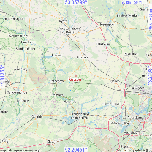
Kotzen GPS coordinates[2]
52° 37' 59.988" North, 12° 31' 0.012" East
| Map corner | latitude | longitude |
|---|---|---|
| Upper-left | 53.05799°, | 11.81355° |
| Center: | 52.63333°, | 12.51667° |
| Lower-right: | 52.20451°, | 13.2198° |
| Map W x H: | 94.9×94.9 km | = 59×59mi |
| max Lat: | 55.01917° ⇑20.9% North |
| Kotzen: | 52.63333° |
| min Lat: | ⇓79.1% South 47.40724° |
| min Long | Kotzen | max Long |
| 5.92978° | 12.51667° | 14.98853° |
| W 88.1%⇐ | ⇒11.9% E |
Elevation
Elevation of Kotzen is 32 m = 105 ft, and this is 217.1 m = 712 ft below average elevation for this country.
| Max E: |
1256 m = 4121 ft | 86.3% |
| Avg. | 249.1 m = 817 ft | |
| Kotzen | 32 m = 105 ft | |
Min E: |
-5 m = -16 ft | 13.7% |
See also: Germany elevation on elevation.city.
Geographical zone
Kotzen is located in North temperate zone (between Tropic of Cancer and the Arctic Circle). Distance of this North polar circle is 1548.9 km =962.4 mi to North.| Distance of | km | miles | from Kotzen |
|---|---|---|---|
| North Pole | 4154.8 | 2581.7 | to North |
| Arctic Circle | 1548.9 | 962.4 | to North |
| Tropic Cancer | 3246.4 | 2017.2 | to South |
| Equator | 5852.3 | 3636.4 | to South |


Nearby cities:
15 places around Kotzen: (largest is in red/bold)
• Brandenburg an der Havel
24.2 km =15 mi,  174°
174°
• Dreetz
19.2 km =11.9 mi,  348°
348°
• Friesack
12.4 km =7.7 mi,  20°
20°
• Großderschau
20.1 km =12.5 mi,  330°
330°
• Jahnberge
16.4 km =10.2 mi,  53°
53°
• Nennhausen
3.9 km =2.4 mi,  196°
196°
• Paulinenaue
14 km =8.7 mi,  69°
69°
• Pessin
10.2 km =6.3 mi,  84°
84°
• Premnitz
16 km =9.9 mi,  225°
225°
• Päwesin
18.7 km =11.6 mi,  133°
133°
• Rathenow
12.5 km =7.8 mi,  256°
256°
• Retzow
11.4 km =7.1 mi,  94°
94°
• Rhinow
17.6 km =10.9 mi,  317°
317°
• Roskow
22.5 km =14 mi,  142°
142°
• Schollene
20.7 km =12.9 mi,  283°
283°
Sources, notices
• [Note1] Compared only with cities in Germany existing in our database
• [Src1] Map data: © OpenStreetMap contributors (CC-BY-SA)
• [Src2] Other city data from geonames.org with taken over terms of usage.
• [Src3] Geographical zone / Annual Mean Temperature by Robert A. Rohde @ Wikipedia
