Breddin geodata
Breddin (Brandenburg) is a seat of a fourth-order administrative division; located in Germany in Europe/Berlin (GMT+2) time zone. With population of 1,046 people, there are 7020 cities with bigger population in this country. Compared to other cities in Germany, 81% of cities are located further ↓South; 85% of cities are located further ←West and 81% of cities have higher elevation than Breddin. Note1
Administrative division(s):
- Level 1: Brandenburg
- Level 3: Landkreis Ostprignitz-Ruppin
- Level 4: Breddin


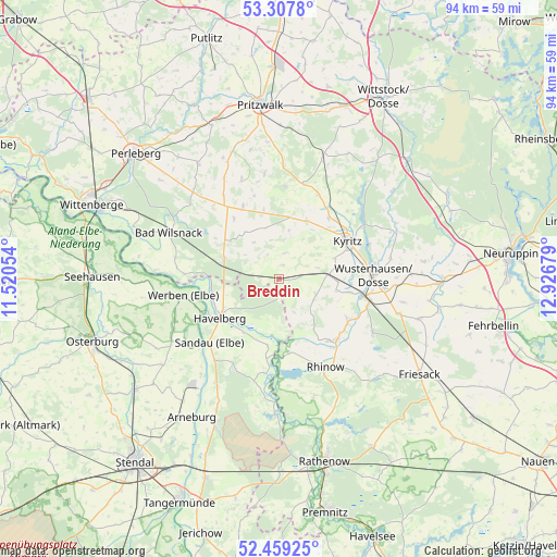
Breddin GPS coordinates[2]
52° 53' 8.16" North, 12° 13' 25.176" East
| Map corner | latitude | longitude |
|---|---|---|
| Upper-left | 53.3078°, | 11.52054° |
| Center: | 52.8856°, | 12.22366° |
| Lower-right: | 52.45925°, | 12.92679° |
| Map W x H: | 94.3×94.3 km | = 58.6×58.6mi |
| max Lat: | 55.01917° ⇑19% North |
| Breddin: | 52.8856° |
| min Lat: | ⇓81% South 47.40724° |
| min Long | Breddin | max Long |
| 5.92978° | 12.22366° | 14.98853° |
| W 85%⇐ | ⇒15% E |
Elevation
Elevation of Breddin is 44 m = 144 ft, and this is 205.1 m = 673 ft below average elevation for this country.
| Max E: |
1256 m = 4121 ft | 81% |
| Avg. | 249.1 m = 817 ft | |
| Breddin | 44 m = 144 ft | |
Min E: |
-5 m = -16 ft | 19% |
See also: Germany elevation on elevation.city.
Geographical zone
Breddin is located in North temperate zone (between Tropic of Cancer and the Arctic Circle). Distance of this North polar circle is 1520.8 km =945 mi to North.| Distance of | km | miles | from Breddin |
|---|---|---|---|
| North Pole | 4126.7 | 2564.2 | to North |
| Arctic Circle | 1520.8 | 945 | to North |
| Tropic Cancer | 3274.4 | 2034.6 | to South |
| Equator | 5880.3 | 3653.8 | to South |


Nearby cities:
15 places around Breddin: (largest is in red/bold)
• Bad Wilsnack
20 km =12.4 mi,  293°
293°
• Behrendorf
18.9 km =11.7 mi,  249°
249°
• Dreetz
18.3 km =11.4 mi,  120°
120°
• Großderschau
14.3 km =8.9 mi,  137°
137°
• Gumtow
11 km =6.8 mi,  9°
9°
• Havelberg
11.7 km =7.3 mi,  238°
238°
• Kamern
17 km =10.6 mi,  206°
206°
• Kyritz
13.2 km =8.2 mi,  61°
61°
• Legde
17.9 km =11.1 mi,  281°
281°
• Plattenburg
15.4 km =9.6 mi,  302°
302°
• Rhinow
17 km =10.6 mi,  152°
152°
• Sandau
16 km =9.9 mi,  228°
228°
• Schollene
23.2 km =14.4 mi,  180°
180°
• Werben
16.4 km =10.2 mi,  260°
260°
• Wusterhausen
15.9 km =9.9 mi,  87°
87°
Sources, notices
• [Note1] Compared only with cities in Germany existing in our database
• [Src1] Map data: © OpenStreetMap contributors (CC-BY-SA)
• [Src2] Other city data from geonames.org with taken over terms of usage.
• [Src3] Geographical zone / Annual Mean Temperature by Robert A. Rohde @ Wikipedia
