Arneburg geodata
Arneburg (Saxony-Anhalt) is a populated place; located in Germany in Europe/Berlin (GMT+2) time zone. With population of 1,754 people, there are 5419 cities with bigger population in this country. Compared to other cities in Germany, 79.4% of cities are located further ↓South; 81.8% of cities are located further ←West and 77% of cities have higher elevation than Arneburg. Note1


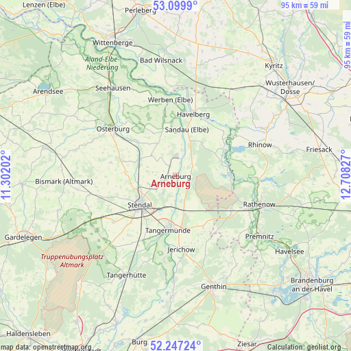
Arneburg GPS coordinates[2]
52° 40' 32.34" North, 12° 0' 18.504" East
| Map corner | latitude | longitude |
|---|---|---|
| Upper-left | 53.0999°, | 11.30202° |
| Center: | 52.67565°, | 12.00514° |
| Lower-right: | 52.24724°, | 12.70827° |
| Map W x H: | 94.8×94.8 km | = 58.9×58.9mi |
| max Lat: | 55.01917° ⇑20.6% North |
| Arneburg: | 52.67565° |
| min Lat: | ⇓79.4% South 47.40724° |
| min Long | Arneburg | max Long |
| 5.92978° | 12.00514° | 14.98853° |
| W 81.8%⇐ | ⇒18.2% E |
Elevation
Elevation of Arneburg is 56 m = 184 ft, and this is 193.1 m = 634 ft below average elevation for this country.
| Max E: |
1256 m = 4121 ft | 77% |
| Avg. | 249.1 m = 817 ft | |
| Arneburg | 56 m = 184 ft | |
Min E: |
-5 m = -16 ft | 23% |
See also: Germany elevation on elevation.city.
Geographical zone
Arneburg is located in North temperate zone (between Tropic of Cancer and the Arctic Circle). Distance of this North polar circle is 1544.2 km =959.5 mi to North.| Distance of | km | miles | from Arneburg |
|---|---|---|---|
| North Pole | 4150.1 | 2578.8 | to North |
| Arctic Circle | 1544.2 | 959.5 | to North |
| Tropic Cancer | 3251.1 | 2020.1 | to South |
| Equator | 5857 | 3639.4 | to South |


Nearby cities:
15 places around Arneburg: (largest is in red/bold)
• Fischbeck
15.1 km =9.4 mi,  177°
177°
• Goldbeck
10.8 km =6.7 mi,  295°
295°
• Hassel
6.7 km =4.2 mi,  232°
232°
• Hohenberg-Krusemark
6.7 km =4.2 mi,  324°
324°
• Iden
13.1 km =8.1 mi,  331°
331°
• Jarchau
7.7 km =4.8 mi,  252°
252°
• Kamern
10.9 km =6.8 mi,  41°
41°
• Klietz
4.3 km =2.7 mi,  100°
100°
• Sandau
13 km =8.1 mi,  12°
12°
• Schollene
14.4 km =8.9 mi,  89°
89°
• Schönhausen
10.8 km =6.7 mi,  167°
167°
• Stendal
12.5 km =7.8 mi, 232°
• Tangermünde
14.7 km =9.1 mi,  187°
187°
• Uenglingen
14.7 km =9.1 mi,  244°
244°
• Wust
15.6 km =9.7 mi,  151°
151°
Sources, notices
• [Note1] Compared only with cities in Germany existing in our database
• [Src1] Map data: © OpenStreetMap contributors (CC-BY-SA)
• [Src2] Other city data from geonames.org with taken over terms of usage.
• [Src3] Geographical zone / Annual Mean Temperature by Robert A. Rohde @ Wikipedia
