Reinheim geodata
Reinheim (Hesse) is a populated place; located in Germany in Europe/Berlin (GMT+2) time zone. With population of 17,841 people, there are 890 cities with bigger population in this country. Compared to other cities in Germany, 68.3% of cities are located further ↑North; 67.4% of cities are located further →East and 57.8% of cities have higher elevation than Reinheim. Note1
Administrative division(s):
- Level 1: Hesse
- Level 2: Regierungsbezirk Darmstadt
- Level 3: Landkreis Darmstadt-Dieburg
- Level 4: Reinheim


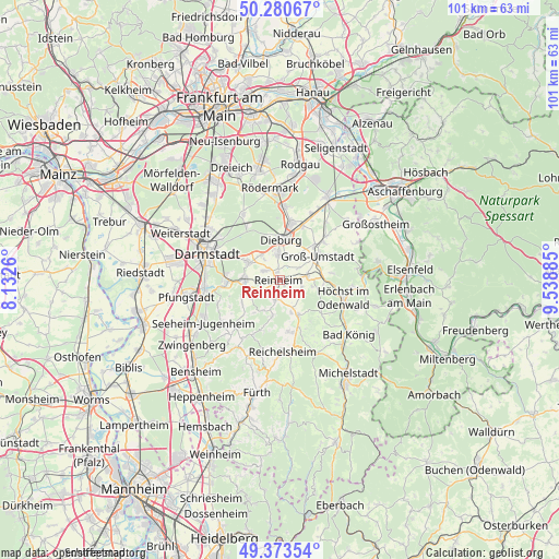
Reinheim GPS coordinates[2]
49° 49' 45.228" North, 8° 50' 8.592" East
| Map corner | latitude | longitude |
|---|---|---|
| Upper-left | 50.28067°, | 8.1326° |
| Center: | 49.82923°, | 8.83572° |
| Lower-right: | 49.37354°, | 9.53885° |
| Map W x H: | 100.9×100.9 km | = 62.7×62.7mi |
| max Lat: | 55.01917° ⇑68.3% North |
| Reinheim: | 49.82923° |
| min Lat: | ⇓31.7% South 47.40724° |
| min Long | Reinheim | max Long |
| 5.92978° | 8.83572° | 14.98853° |
| W 32.6%⇐ | ⇒67.4% E |
Elevation
Elevation of Reinheim is 169 m = 554 ft, and this is 80.1 m = 263 ft below average elevation for this country.
| Max E: |
1256 m = 4121 ft | 57.8% |
| Avg. | 249.1 m = 817 ft | |
| Reinheim | 169 m = 554 ft | |
Min E: |
-5 m = -16 ft | 42.2% |
See also: Germany elevation on elevation.city.
Geographical zone
Reinheim is located in North temperate zone (between Tropic of Cancer and the Arctic Circle). Distance of this North polar circle is 1860.7 km =1156.2 mi to North.| Distance of | km | miles | from Reinheim |
|---|---|---|---|
| North Pole | 4466.6 | 2775.4 | to North |
| Arctic Circle | 1860.7 | 1156.2 | to North |
| Tropic Cancer | 2934.6 | 1823.5 | to South |
| Equator | 5540.5 | 3442.7 | to South |


Nearby cities:
15 places around Reinheim: (largest is in red/bold)
• Brensbach
7.1 km =4.4 mi,  150°
150°
• Darmstadt
14.1 km =8.8 mi,  289°
289°
• Dieburg
7.6 km =4.7 mi,  5°
5°
• Eppertshausen
13.6 km =8.5 mi, 5°
• Fränkisch-Crumbach
9.4 km =5.8 mi,  169°
169°
• Groß-Bieberau
3.3 km =2.1 mi,  194°
194°
• Groß-Umstadt
8.2 km =5.1 mi,  57°
57°
• Groß-Zimmern
5 km =3.1 mi,  354°
354°
• Höchst im Odenwald
12.2 km =7.6 mi,  105°
105°
• Lützelbach
10.9 km =6.8 mi,  207°
207°
• Messel
13.9 km =8.6 mi,  330°
330°
• Münster
10.7 km =6.6 mi, 12°
• Ober-Ramstadt
6.2 km =3.9 mi,  271°
271°
• Reichelsheim
13 km =8.1 mi,  178°
178°
• Roßdorf
6.3 km =3.9 mi,  302°
302°
Sources, notices
• [Note1] Compared only with cities in Germany existing in our database
• [Src1] Map data: © OpenStreetMap contributors (CC-BY-SA)
• [Src2] Other city data from geonames.org with taken over terms of usage.
• [Src3] Geographical zone / Annual Mean Temperature by Robert A. Rohde @ Wikipedia
