Lützelbach geodata
Lützelbach (Hesse) is a populated place; located in Germany in Europe/Berlin (GMT+2) time zone. With population of 7,321 people, there are 2111 cities with bigger population in this country. Compared to other cities in Germany, 70.3% of cities are located further ↑North; 68.3% of cities are located further →East and 75.3% of cities have lower elevation than Lützelbach. Note1
Administrative division(s):
- Level 1: Hesse
- Level 2: Regierungsbezirk Darmstadt
- Level 3: Landkreis Darmstadt-Dieburg
- Level 4: Modautal


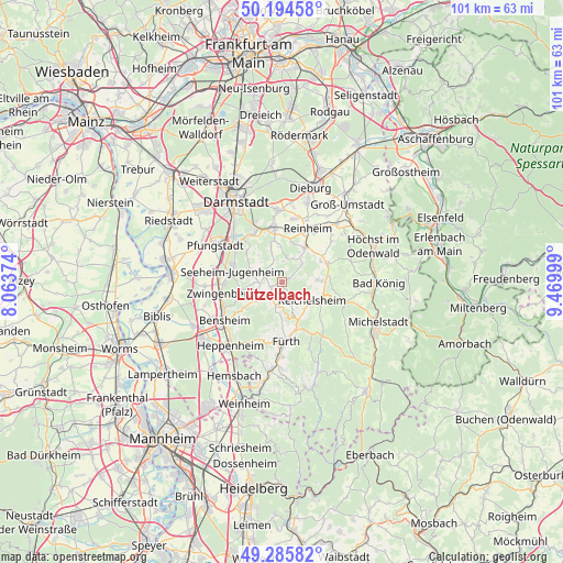
Lützelbach GPS coordinates[2]
49° 44' 32.388" North, 8° 46' 0.732" East
| Map corner | latitude | longitude |
|---|---|---|
| Upper-left | 50.19458°, | 8.06374° |
| Center: | 49.74233°, | 8.76687° |
| Lower-right: | 49.28582°, | 9.46999° |
| Map W x H: | 101×101 km | = 62.8×62.8mi |
| max Lat: | 55.01917° ⇑70.3% North |
| Lützelbach: | 49.74233° |
| min Lat: | ⇓29.7% South 47.40724° |
| min Long | Lützelbach | max Long |
| 5.92978° | 8.76687° | 14.98853° |
| W 31.7%⇐ | ⇒68.3% E |
Elevation
Elevation of Lützelbach is 400 m = 1312 ft, and this is 150.9 m = 495 ft above average elevation for this country.
| Max E: |
1256 m = 4121 ft | 24.7% |
| Lützelbach | 400 m 1312 ft | |
| Avg. | 249.1 m = 817 ft | |
Min E: |
-5 m = -16 ft | 75.3% |
See also: Germany elevation on elevation.city.
Geographical zone
Lützelbach is located in North temperate zone (between Tropic of Cancer and the Arctic Circle). Distance of this North polar circle is 1870.3 km =1162.2 mi to North.| Distance of | km | miles | from Lützelbach |
|---|---|---|---|
| North Pole | 4476.2 | 2781.4 | to North |
| Arctic Circle | 1870.3 | 1162.2 | to North |
| Tropic Cancer | 2924.9 | 1817.4 | to South |
| Equator | 5530.8 | 3436.7 | to South |


Nearby cities:
15 places around Lützelbach: (largest is in red/bold)
• Alsbach-Hähnlein
12.3 km =7.6 mi,  268°
268°
• Bensheim
12.5 km =7.8 mi,  238°
238°
• Bickenbach
10.9 km =6.8 mi,  279°
279°
• Brensbach
9.1 km =5.7 mi,  67°
67°
• Fränkisch-Crumbach
6.6 km =4.1 mi,  86°
86°
• Fürth
10.3 km =6.4 mi,  172°
172°
• Groß-Bieberau
7.7 km =4.8 mi,  32°
32°
• Lindenfels
6.6 km =4.1 mi, 170°
• Ober-Ramstadt
9.9 km =6.2 mi,  352°
352°
• Reichelsheim
6.2 km =3.9 mi,  122°
122°
• Reinheim
10.9 km =6.8 mi, 27°
• Rimbach
13 km =8.1 mi,  181°
181°
• Roßdorf
13.1 km =8.1 mi,  358°
358°
• Seeheim-Jugenheim
8.6 km =5.3 mi,  286°
286°
• Zwingenberg
11.4 km =7.1 mi,  259°
259°
Sources, notices
• [Note1] Compared only with cities in Germany existing in our database
• [Src1] Map data: © OpenStreetMap contributors (CC-BY-SA)
• [Src2] Other city data from geonames.org with taken over terms of usage.
• [Src3] Geographical zone / Annual Mean Temperature by Robert A. Rohde @ Wikipedia
