Eppertshausen geodata
Eppertshausen (Hesse) is a seat of a fourth-order administrative division; located in Germany in Europe/Berlin (GMT+2) time zone. With population of 5,838 people, there are 2514 cities with bigger population in this country. Compared to other cities in Germany, 65% of cities are located further ↑North; 67.2% of cities are located further →East and 62% of cities have higher elevation than Eppertshausen. Note1
Administrative division(s):
- Level 1: Hesse
- Level 2: Regierungsbezirk Darmstadt
- Level 3: Landkreis Darmstadt-Dieburg
- Level 4: Eppertshausen


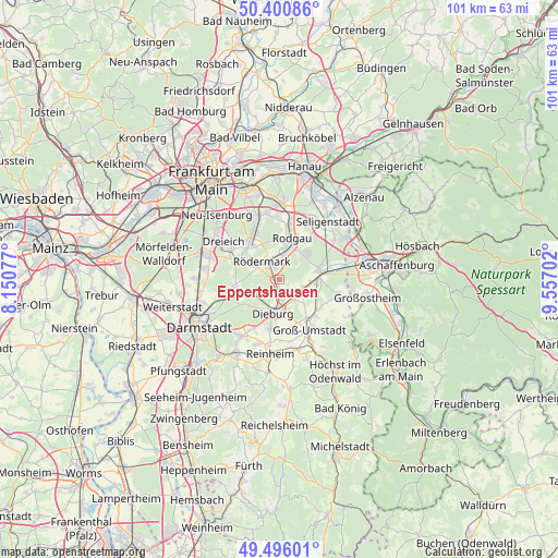
Eppertshausen GPS coordinates[2]
49° 57' 2.016" North, 8° 51' 14.004" East
| Map corner | latitude | longitude |
|---|---|---|
| Upper-left | 50.40086°, | 8.15077° |
| Center: | 49.95056°, | 8.85389° |
| Lower-right: | 49.49601°, | 9.55702° |
| Map W x H: | 100.6×100.6 km | = 62.5×62.5mi |
| max Lat: | 55.01917° ⇑65% North |
| Eppertshausen: | 49.95056° |
| min Lat: | ⇓35% South 47.40724° |
| min Long | Eppertshausen | max Long |
| 5.92978° | 8.85389° | 14.98853° |
| W 32.8%⇐ | ⇒67.2% E |
Elevation
Elevation of Eppertshausen is 138 m = 453 ft, and this is 111.1 m = 365 ft below average elevation for this country.
| Max E: |
1256 m = 4121 ft | 62% |
| Avg. | 249.1 m = 817 ft | |
| Eppertshausen | 138 m = 453 ft | |
Min E: |
-5 m = -16 ft | 38% |
See also: Germany elevation on elevation.city.
Geographical zone
Eppertshausen is located in North temperate zone (between Tropic of Cancer and the Arctic Circle). Distance of this North polar circle is 1847.2 km =1147.8 mi to North.| Distance of | km | miles | from Eppertshausen |
|---|---|---|---|
| North Pole | 4453.1 | 2767 | to North |
| Arctic Circle | 1847.2 | 1147.8 | to North |
| Tropic Cancer | 2948.1 | 1831.9 | to South |
| Equator | 5554 | 3451.1 | to South |


Nearby cities:
15 places around Eppertshausen: (largest is in red/bold)
• Babenhausen
7.2 km =4.5 mi,  76°
76°
• Dieburg
5.9 km =3.7 mi,  185°
185°
• Dietzenbach
8.5 km =5.3 mi,  320°
320°
• Dreieich
13.7 km =8.5 mi,  304°
304°
• Groß-Umstadt
10.7 km =6.6 mi,  148°
148°
• Groß-Zimmern
8.7 km =5.4 mi, 191°
• Heusenstamm
12.3 km =7.6 mi,  341°
341°
• Messel
8.2 km =5.1 mi,  260°
260°
• Münster
3.2 km =2 mi,  162°
162°
• Obertshausen
13.4 km =8.3 mi,  359°
359°
• Reinheim
13.6 km =8.5 mi, 185°
• Rodgau
8.7 km =5.4 mi,  15°
15°
• Roßdorf
12.1 km =7.5 mi,  213°
213°
• Schaafheim
11.5 km =7.1 mi,  104°
104°
• Seligenstadt
13.4 km =8.3 mi,  39°
39°
Sources, notices
• [Note1] Compared only with cities in Germany existing in our database
• [Src1] Map data: © OpenStreetMap contributors (CC-BY-SA)
• [Src2] Other city data from geonames.org with taken over terms of usage.
• [Src3] Geographical zone / Annual Mean Temperature by Robert A. Rohde @ Wikipedia
