Münster geodata
Münster (Hesse) is a seat of a fourth-order administrative division; located in Germany in Europe/Berlin (GMT+2) time zone. With population of 14,018 people, there are 1134 cities with bigger population in this country. Compared to other cities in Germany, 65.8% of cities are located further ↑North; 67% of cities are located further →East and 61.9% of cities have higher elevation than Münster. Note1
Administrative division(s):
- Level 1: Hesse
- Level 2: Regierungsbezirk Darmstadt
- Level 3: Landkreis Darmstadt-Dieburg
- Level 4: Münster


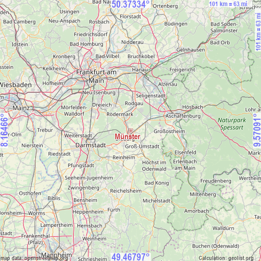
Münster GPS coordinates[2]
49° 55' 22.008" North, 8° 52' 4.008" East
| Map corner | latitude | longitude |
|---|---|---|
| Upper-left | 50.37334°, | 8.16466° |
| Center: | 49.92278°, | 8.86778° |
| Lower-right: | 49.46797°, | 9.57091° |
| Map W x H: | 100.7×100.7 km | = 62.6×62.6mi |
| max Lat: | 55.01917° ⇑65.8% North |
| Münster: | 49.92278° |
| min Lat: | ⇓34.2% South 47.40724° |
| min Long | Münster | max Long |
| 5.92978° | 8.86778° | 14.98853° |
| W 33%⇐ | ⇒67% E |
Elevation
Elevation of Münster is 139 m = 456 ft, and this is 110.1 m = 361 ft below average elevation for this country.
| Max E: |
1256 m = 4121 ft | 61.9% |
| Avg. | 249.1 m = 817 ft | |
| Münster | 139 m = 456 ft | |
Min E: |
-5 m = -16 ft | 38.1% |
See also: Germany elevation on elevation.city.
Geographical zone
Münster is located in North temperate zone (between Tropic of Cancer and the Arctic Circle). Distance of this North polar circle is 1850.3 km =1149.7 mi to North.| Distance of | km | miles | from Münster |
|---|---|---|---|
| North Pole | 4456.2 | 2769 | to North |
| Arctic Circle | 1850.3 | 1149.7 | to North |
| Tropic Cancer | 2945 | 1829.9 | to South |
| Equator | 5550.9 | 3449.2 | to South |


Nearby cities:
15 places around Münster: (largest is in red/bold)
• Babenhausen
7.6 km =4.7 mi,  51°
51°
• Dieburg
3.2 km =2 mi,  208°
208°
• Dietzenbach
11.6 km =7.2 mi,  326°
326°
• Eppertshausen
3.2 km =2 mi,  342°
342°
• Groß-Bieberau
13.9 km =8.6 mi,  192°
192°
• Groß-Umstadt
7.5 km =4.7 mi,  142°
142°
• Groß-Zimmern
6.1 km =3.8 mi, 207°
• Großostheim
14.9 km =9.3 mi,  91°
91°
• Messel
9.3 km =5.8 mi,  280°
280°
• Ober-Ramstadt
13.3 km =8.3 mi,  219°
219°
• Reinheim
10.7 km =6.6 mi, 192°
• Rodgau
11.6 km =7.2 mi,  6°
6°
• Roßdorf
10.3 km =6.4 mi,  227°
227°
• Schaafheim
10.1 km =6.3 mi, 89°
• Seligenstadt
15.4 km =9.6 mi,  29°
29°
Sources, notices
• [Note1] Compared only with cities in Germany existing in our database
• [Src1] Map data: © OpenStreetMap contributors (CC-BY-SA)
• [Src2] Other city data from geonames.org with taken over terms of usage.
• [Src3] Geographical zone / Annual Mean Temperature by Robert A. Rohde @ Wikipedia
