Rehna geodata
Rehna (Mecklenburg-Vorpommern) is a populated place; located in Germany in Europe/Berlin (GMT+2) time zone. With population of 2,897 people, there are 4099 cities with bigger population in this country. Compared to other cities in Germany, 89.8% of cities are located further ↓South; 67.7% of cities are located further ←West and 88.3% of cities have higher elevation than Rehna. Note1
Administrative division(s):
- Level 1: Mecklenburg-Vorpommern
- Level 3: Nordwestmecklenburg
- Level 4: Rehna


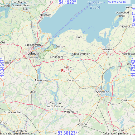
Rehna GPS coordinates[2]
53° 46' 43.572" North, 11° 2' 57.444" East
| Map corner | latitude | longitude |
|---|---|---|
| Upper-left | 54.1922°, | 10.34617° |
| Center: | 53.77877°, | 11.04929° |
| Lower-right: | 53.36123°, | 11.75242° |
| Map W x H: | 92.4×92.4 km | = 57.4×57.4mi |
| max Lat: | 55.01917° ⇑10.2% North |
| Rehna: | 53.77877° |
| min Lat: | ⇓89.8% South 47.40724° |
| min Long | Rehna | max Long |
| 5.92978° | 11.04929° | 14.98853° |
| W 67.7%⇐ | ⇒32.3% E |
Elevation
Elevation of Rehna is 26 m = 85 ft, and this is 223.1 m = 732 ft below average elevation for this country.
| Max E: |
1256 m = 4121 ft | 88.3% |
| Avg. | 249.1 m = 817 ft | |
| Rehna | 26 m = 85 ft | |
Min E: |
-5 m = -16 ft | 11.7% |
See also: Germany elevation on elevation.city.
Geographical zone
Rehna is located in North temperate zone (between Tropic of Cancer and the Arctic Circle). Distance of this North polar circle is 1421.5 km =883.3 mi to North.| Distance of | km | miles | from Rehna |
|---|---|---|---|
| North Pole | 4027.4 | 2502.5 | to North |
| Arctic Circle | 1421.5 | 883.3 | to North |
| Tropic Cancer | 3373.7 | 2096.3 | to South |
| Equator | 5979.6 | 3715.6 | to South |


Nearby cities:
15 places around Rehna: (largest is in red/bold)
• Börzow
10.3 km =6.4 mi,  29°
29°
• Carlow
7.7 km =4.8 mi,  252°
252°
• Dragun
14 km =8.7 mi,  124°
124°
• Gadebusch
9.7 km =6 mi,  152°
152°
• Grevesmühlen
13.3 km =8.3 mi,  44°
44°
• Kittlitz
15.4 km =9.6 mi,  214°
214°
• Krembz
14.3 km =8.9 mi,  176°
176°
• Mallentin
11.6 km =7.2 mi,  8°
8°
• Mustin
15.2 km =9.4 mi,  225°
225°
• Mühlen Eichsen
13.4 km =8.3 mi,  100°
100°
• Roggendorf
9.8 km =6.1 mi,  193°
193°
• Rüting
11.4 km =7.1 mi,  81°
81°
• Testorf-Steinfort
14.5 km =9 mi,  90°
90°
• Upahl
11.9 km =7.4 mi,  67°
67°
• Veelböken
9.4 km =5.8 mi,  110°
110°
Sources, notices
• [Note1] Compared only with cities in Germany existing in our database
• [Src1] Map data: © OpenStreetMap contributors (CC-BY-SA)
• [Src2] Other city data from geonames.org with taken over terms of usage.
• [Src3] Geographical zone / Annual Mean Temperature by Robert A. Rohde @ Wikipedia
