Gadebusch geodata
Gadebusch (Mecklenburg-Vorpommern) is a populated place; located in Germany in Europe/Berlin (GMT+2) time zone. With population of 6,030 people, there are 2451 cities with bigger population in this country. Compared to other cities in Germany, 88.7% of cities are located further ↓South; 68.7% of cities are located further ←West and 84.9% of cities have higher elevation than Gadebusch. Note1
Administrative division(s):
- Level 1: Mecklenburg-Vorpommern
- Level 3: Nordwestmecklenburg
- Level 4: Gadebusch


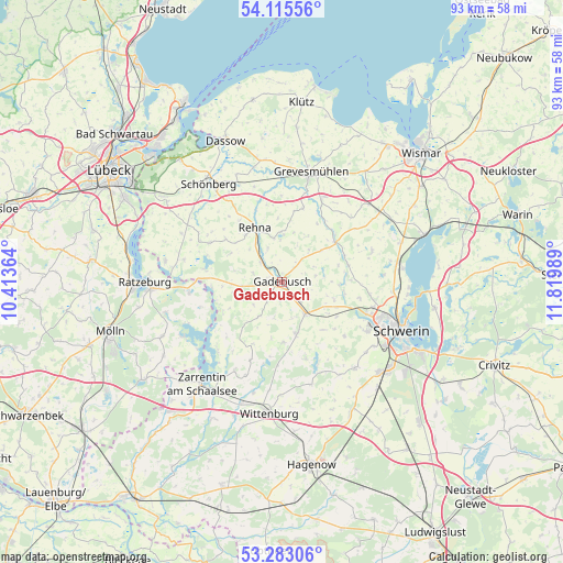
Gadebusch GPS coordinates[2]
53° 42' 4.932" North, 11° 7' 0.336" East
| Map corner | latitude | longitude |
|---|---|---|
| Upper-left | 54.11556°, | 10.41364° |
| Center: | 53.70137°, | 11.11676° |
| Lower-right: | 53.28306°, | 11.81989° |
| Map W x H: | 92.6×92.6 km | = 57.5×57.5mi |
| max Lat: | 55.01917° ⇑11.3% North |
| Gadebusch: | 53.70137° |
| min Lat: | ⇓88.7% South 47.40724° |
| min Long | Gadebusch | max Long |
| 5.92978° | 11.11676° | 14.98853° |
| W 68.7%⇐ | ⇒31.3% E |
Elevation
Elevation of Gadebusch is 35 m = 115 ft, and this is 214.1 m = 702 ft below average elevation for this country.
| Max E: |
1256 m = 4121 ft | 84.9% |
| Avg. | 249.1 m = 817 ft | |
| Gadebusch | 35 m = 115 ft | |
Min E: |
-5 m = -16 ft | 15.1% |
See also: Germany elevation on elevation.city.
Geographical zone
Gadebusch is located in North temperate zone (between Tropic of Cancer and the Arctic Circle). Distance of this North polar circle is 1430.1 km =888.6 mi to North.| Distance of | km | miles | from Gadebusch |
|---|---|---|---|
| North Pole | 4036 | 2507.9 | to North |
| Arctic Circle | 1430.1 | 888.6 | to North |
| Tropic Cancer | 3365.1 | 2091 | to South |
| Equator | 5971 | 3710.2 | to South |


Nearby cities:
15 places around Gadebusch: (largest is in red/bold)
• Brüsewitz
8.8 km =5.5 mi,  108°
108°
• Carlow
13.4 km =8.3 mi,  298°
298°
• Cramonshagen
10.4 km =6.5 mi,  87°
87°
• Dragun
7.2 km =4.5 mi,  84°
84°
• Gottesgabe
11.7 km =7.3 mi,  131°
131°
• Kittlitz
13.8 km =8.6 mi,  252°
252°
• Krembz
6.7 km =4.2 mi,  213°
213°
• Lützow
6.6 km =4.1 mi,  143°
143°
• Mühlen Eichsen
10.8 km =6.7 mi,  54°
54°
• Pokrent
6.1 km =3.8 mi,  161°
161°
• Rehna
9.7 km =6 mi,  332°
332°
• Roggendorf
6.8 km =4.2 mi,  262°
262°
• Rüting
12.4 km =7.7 mi,  33°
33°
• Testorf-Steinfort
13.1 km =8.1 mi, 50°
• Veelböken
6.9 km =4.3 mi,  39°
39°
Sources, notices
• [Note1] Compared only with cities in Germany existing in our database
• [Src1] Map data: © OpenStreetMap contributors (CC-BY-SA)
• [Src2] Other city data from geonames.org with taken over terms of usage.
• [Src3] Geographical zone / Annual Mean Temperature by Robert A. Rohde @ Wikipedia
