Nittendorf geodata
Nittendorf (Bavaria) is a populated place; located in Germany in Europe/Berlin (GMT+2) time zone. With population of 9,226 people, there are 1748 cities with bigger population in this country. Compared to other cities in Germany, 82.7% of cities are located further ↑North; 81.3% of cities are located further ←West and 77.2% of cities have lower elevation than Nittendorf. Note1
Administrative division(s):
- Level 1: Bavaria
- Level 2: Upper Palatinate
- Level 3: Landkreis Regensburg
- Level 4: Nittendorf, Markt


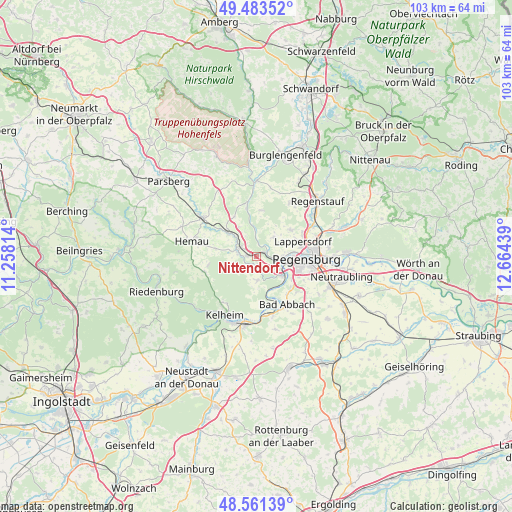
Nittendorf GPS coordinates[2]
49° 1' 28.524" North, 11° 57' 40.536" East
| Map corner | latitude | longitude |
|---|---|---|
| Upper-left | 49.48352°, | 11.25814° |
| Center: | 49.02459°, | 11.96126° |
| Lower-right: | 48.56139°, | 12.66439° |
| Map W x H: | 102.5×102.5 km | = 63.7×63.7mi |
| max Lat: | 55.01917° ⇑82.7% North |
| Nittendorf: | 49.02459° |
| min Lat: | ⇓17.3% South 47.40724° |
| min Long | Nittendorf | max Long |
| 5.92978° | 11.96126° | 14.98853° |
| W 81.3%⇐ | ⇒18.7% E |
Elevation
Elevation of Nittendorf is 413 m = 1355 ft, and this is 163.9 m = 538 ft above average elevation for this country.
| Max E: |
1256 m = 4121 ft | 22.8% |
| Nittendorf | 413 m 1355 ft | |
| Avg. | 249.1 m = 817 ft | |
Min E: |
-5 m = -16 ft | 77.2% |
See also: Germany elevation on elevation.city.
Geographical zone
Nittendorf is located in North temperate zone (between Tropic of Cancer and the Arctic Circle). Distance of this North polar circle is 1950.2 km =1211.8 mi to North.| Distance of | km | miles | from Nittendorf |
|---|---|---|---|
| North Pole | 4556 | 2831 | to North |
| Arctic Circle | 1950.2 | 1211.8 | to North |
| Tropic Cancer | 2845.1 | 1767.9 | to South |
| Equator | 5451 | 3387.1 | to South |


Nearby cities:
15 places around Nittendorf: (largest is in red/bold)
• Bad Abbach
11.4 km =7.1 mi,  147°
147°
• Brunn
9.5 km =5.9 mi,  331°
331°
• Deuerling
4 km =2.5 mi,  290°
290°
• Duggendorf
10.7 km =6.6 mi,  342°
342°
• Ihrlerstein
12.3 km =7.6 mi,  214°
214°
• Lappersdorf
9.8 km =6.1 mi,  75°
75°
• Painten
10.8 km =6.7 mi,  253°
253°
• Pentling
8.5 km =5.3 mi,  122°
122°
• Pettendorf
5.3 km =3.3 mi,  40°
40°
• Pielenhofen
5.3 km =3.3 mi,  356°
356°
• Regensburg
10.3 km =6.4 mi,  95°
95°
• Reinhausen
11.1 km =6.9 mi,  86°
86°
• Sinzing
5.9 km =3.7 mi, 117°
• Wolfsegg
9.3 km =5.8 mi,  7°
7°
• Zeitlarn
12.5 km =7.8 mi,  61°
61°
Sources, notices
• [Note1] Compared only with cities in Germany existing in our database
• [Src1] Map data: © OpenStreetMap contributors (CC-BY-SA)
• [Src2] Other city data from geonames.org with taken over terms of usage.
• [Src3] Geographical zone / Annual Mean Temperature by Robert A. Rohde @ Wikipedia
