Lappersdorf geodata
Lappersdorf (Bavaria) is a populated place; located in Germany in Europe/Berlin (GMT+2) time zone. With population of 12,744 people, there are 1268 cities with bigger population in this country. Compared to other cities in Germany, 82.5% of cities are located further ↑North; 83.1% of cities are located further ←West and 68.2% of cities have lower elevation than Lappersdorf. Note1
Administrative division(s):
- Level 1: Bavaria
- Level 2: Upper Palatinate
- Level 3: Landkreis Regensburg
- Level 4: Lappersdorf, Markt


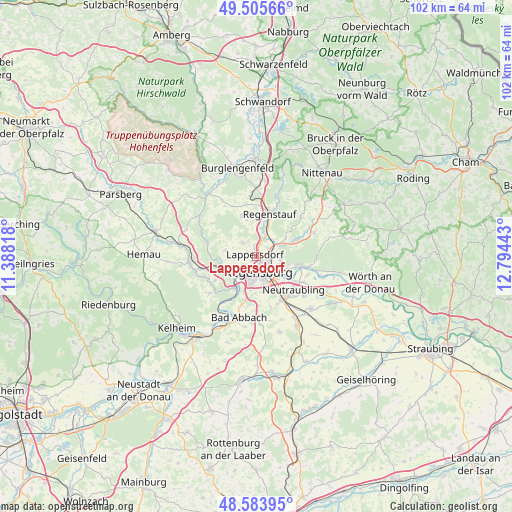
Lappersdorf GPS coordinates[2]
49° 2' 48.984" North, 12° 5' 28.68" East
| Map corner | latitude | longitude |
|---|---|---|
| Upper-left | 49.50566°, | 11.38818° |
| Center: | 49.04694°, | 12.0913° |
| Lower-right: | 48.58395°, | 12.79443° |
| Map W x H: | 102.5×102.5 km | = 63.7×63.7mi |
| max Lat: | 55.01917° ⇑82.5% North |
| Lappersdorf: | 49.04694° |
| min Lat: | ⇓17.5% South 47.40724° |
| min Long | Lappersdorf | max Long |
| 5.92978° | 12.0913° | 14.98853° |
| W 83.1%⇐ | ⇒16.9% E |
Elevation
Elevation of Lappersdorf is 344 m = 1129 ft, and this is 94.9 m = 311 ft above average elevation for this country.
| Max E: |
1256 m = 4121 ft | 31.8% |
| Lappersdorf | 344 m 1129 ft | |
| Avg. | 249.1 m = 817 ft | |
Min E: |
-5 m = -16 ft | 68.2% |
See also: Germany elevation on elevation.city.
Geographical zone
Lappersdorf is located in North temperate zone (between Tropic of Cancer and the Arctic Circle). Distance of this North polar circle is 1947.7 km =1210.2 mi to North.| Distance of | km | miles | from Lappersdorf |
|---|---|---|---|
| North Pole | 4553.6 | 2829.5 | to North |
| Arctic Circle | 1947.7 | 1210.2 | to North |
| Tropic Cancer | 2847.6 | 1769.4 | to South |
| Equator | 5453.5 | 3388.6 | to South |


Nearby cities:
15 places around Lappersdorf: (largest is in red/bold)
• Barbing
9.5 km =5.9 mi,  123°
123°
• Donaustauf
8.4 km =5.2 mi,  100°
100°
• Neutraubling
10.4 km =6.5 mi,  129°
129°
• Nittendorf
9.8 km =6.1 mi,  255°
255°
• Obertraubling
10.5 km =6.5 mi,  148°
148°
• Pentling
7.5 km =4.7 mi,  198°
198°
• Pettendorf
6.3 km =3.9 mi,  284°
284°
• Pielenhofen
10.2 km =6.3 mi,  286°
286°
• Regensburg
3.6 km =2.2 mi,  168°
168°
• Regenstauf
8.6 km =5.3 mi,  19°
19°
• Reinhausen
2.4 km =1.5 mi,  138°
138°
• Sinzing
6.7 km =4.2 mi,  219°
219°
• Tegernheim
6.5 km =4 mi,  113°
113°
• Wenzenbach
8.5 km =5.3 mi,  67°
67°
• Zeitlarn
3.8 km =2.4 mi, 23°
Sources, notices
• [Note1] Compared only with cities in Germany existing in our database
• [Src1] Map data: © OpenStreetMap contributors (CC-BY-SA)
• [Src2] Other city data from geonames.org with taken over terms of usage.
• [Src3] Geographical zone / Annual Mean Temperature by Robert A. Rohde @ Wikipedia
