Wülfrath geodata
Wülfrath (North Rhine-Westphalia) is a populated place; located in Germany in Europe/Berlin (GMT+2) time zone. With population of 22,355 people, there are 674 cities with bigger population in this country. Compared to other cities in Germany, 62.9% of cities are located further ↓South; 92.9% of cities are located further →East and 55% of cities have higher elevation than Wülfrath. Note1
Administrative division(s):
- Level 1: North Rhine-Westphalia
- Level 2: Düsseldorf District
- Level 3: Kreis Mettmann
- Level 4: Wülfrath


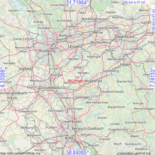
Wülfrath GPS coordinates[2]
51° 16' 55.02" North, 7° 2' 17.556" East
| Map corner | latitude | longitude |
|---|---|---|
| Upper-left | 51.71964°, | 6.33508° |
| Center: | 51.28195°, | 7.03821° |
| Lower-right: | 50.84005°, | 7.74133° |
| Map W x H: | 97.8×97.8 km | = 60.8×60.8mi |
| max Lat: | 55.01917° ⇑37.1% North |
| Wülfrath: | 51.28195° |
| min Lat: | ⇓62.9% South 47.40724° |
| min Long | Wülfrath | max Long |
| 5.92978° | 7.03821° | 14.98853° |
| W 7.1%⇐ | ⇒92.9% E |
Elevation
Elevation of Wülfrath is 189 m = 620 ft, and this is 60.1 m = 197 ft below average elevation for this country.
| Max E: |
1256 m = 4121 ft | 55% |
| Avg. | 249.1 m = 817 ft | |
| Wülfrath | 189 m = 620 ft | |
Min E: |
-5 m = -16 ft | 45% |
See also: Germany elevation on elevation.city.
Geographical zone
Wülfrath is located in North temperate zone (between Tropic of Cancer and the Arctic Circle). Distance of this North polar circle is 1699.2 km =1055.8 mi to North.| Distance of | km | miles | from Wülfrath |
|---|---|---|---|
| North Pole | 4305 | 2675 | to North |
| Arctic Circle | 1699.2 | 1055.8 | to North |
| Tropic Cancer | 3096.1 | 1923.8 | to South |
| Equator | 5702 | 3543.1 | to South |


Nearby cities:
15 places around Wülfrath: (largest is in red/bold)
• Düsseldorf
19.4 km =12.1 mi,  249°
249°
• Düsseldorf-Pempelfort
18.2 km =11.3 mi, 254°
• Erkrath
11.2 km =7 mi,  233°
233°
• Haan
10 km =6.2 mi,  190°
190°
• Hattingen
16.6 km =10.3 mi,  38°
38°
• Heiligenhaus
6.8 km =4.2 mi,  316°
316°
• Hilden
14.7 km =9.1 mi,  210°
210°
• Mettmann
5.6 km =3.5 mi, 231°
• Ratingen
13.2 km =8.2 mi,  277°
277°
• Remscheid
15.6 km =9.7 mi,  136°
136°
• Schwelm
17.8 km =11.1 mi,  88°
88°
• Solingen
12.5 km =7.8 mi,  165°
165°
• Sprockhövel
16 km =9.9 mi,  63°
63°
• Velbert
6 km =3.7 mi,  3°
3°
• Wuppertal
8.2 km =5.1 mi,  110°
110°
Sources, notices
• [Note1] Compared only with cities in Germany existing in our database
• [Src1] Map data: © OpenStreetMap contributors (CC-BY-SA)
• [Src2] Other city data from geonames.org with taken over terms of usage.
• [Src3] Geographical zone / Annual Mean Temperature by Robert A. Rohde @ Wikipedia
