Raschau geodata
Raschau (Saxony) is a populated place; located in Germany in Europe/Berlin (GMT+2) time zone. With population of 4,085 people, there are 3245 cities with bigger population in this country. Compared to other cities in Germany, 52.2% of cities are located further ↑North; 91% of cities are located further ←West and 83% of cities have lower elevation than Raschau. Note1


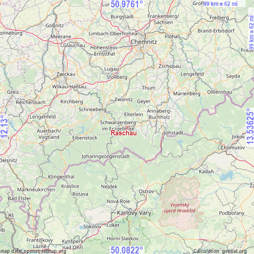
Raschau GPS coordinates[2]
50° 31' 52.572" North, 12° 49' 59.232" East
| Map corner | latitude | longitude |
|---|---|---|
| Upper-left | 50.9761°, | 12.13° |
| Center: | 50.53127°, | 12.83312° |
| Lower-right: | 50.0822°, | 13.53625° |
| Map W x H: | 99.4×99.4 km | = 61.8×61.8mi |
| max Lat: | 55.01917° ⇑52.2% North |
| Raschau: | 50.53127° |
| min Lat: | ⇓47.8% South 47.40724° |
| min Long | Raschau | max Long |
| 5.92978° | 12.83312° | 14.98853° |
| W 91%⇐ | ⇒9% E |
Elevation
Elevation of Raschau is 453 m = 1486 ft, and this is 203.9 m = 669 ft above average elevation for this country.
| Max E: |
1256 m = 4121 ft | 17% |
| Raschau | 453 m 1486 ft | |
| Avg. | 249.1 m = 817 ft | |
Min E: |
-5 m = -16 ft | 83% |
See also: Germany elevation on elevation.city.
Geographical zone
Raschau is located in North temperate zone (between Tropic of Cancer and the Arctic Circle). Distance of this North polar circle is 1782.6 km =1107.7 mi to North.| Distance of | km | miles | from Raschau |
|---|---|---|---|
| North Pole | 4388.5 | 2726.9 | to North |
| Arctic Circle | 1782.6 | 1107.7 | to North |
| Tropic Cancer | 3012.6 | 1871.9 | to South |
| Equator | 5618.6 | 3491.2 | to South |


Nearby cities:
15 places around Raschau: (largest is in red/bold)
• Beierfeld
4.8 km =3 mi,  321°
321°
• Bernsbach
6.8 km =4.2 mi, 317°
• Bockau
10.4 km =6.5 mi,  276°
276°
• Breitenbrunn
7.8 km =4.8 mi,  217°
217°
• Crottendorf
8.4 km =5.2 mi,  101°
101°
• Elterlein
5.6 km =3.5 mi,  26°
26°
• Erlabrunn
11 km =6.8 mi,  233°
233°
• Grünhain
5.7 km =3.5 mi,  341°
341°
• Lauter
7.8 km =4.8 mi,  296°
296°
• Markersbach
2.1 km =1.3 mi,  76°
76°
• Pöhla
2.4 km =1.5 mi,  204°
204°
• Rittersgrün
6.3 km =3.9 mi,  206°
206°
• Scheibenberg
5.7 km =3.5 mi, 79°
• Schlettau
9 km =5.6 mi,  70°
70°
• Schwarzenberg
3.5 km =2.2 mi, 282°
Sources, notices
• [Note1] Compared only with cities in Germany existing in our database
• [Src1] Map data: © OpenStreetMap contributors (CC-BY-SA)
• [Src2] Other city data from geonames.org with taken over terms of usage.
• [Src3] Geographical zone / Annual Mean Temperature by Robert A. Rohde @ Wikipedia
