Lauter geodata
Lauter (Saxony) is a populated place; located in Germany in Europe/Berlin (GMT+2) time zone. With population of 5,028 people, there are 2816 cities with bigger population in this country. Compared to other cities in Germany, 51.4% of cities are located further ↑North; 90.2% of cities are located further ←West and 84.5% of cities have lower elevation than Lauter. Note1


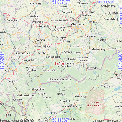
Lauter GPS coordinates[2]
50° 33' 45.504" North, 12° 44' 6.468" East
| Map corner | latitude | longitude |
|---|---|---|
| Upper-left | 51.00717°, | 12.03201° |
| Center: | 50.56264°, | 12.73513° |
| Lower-right: | 50.11387°, | 13.43826° |
| Map W x H: | 99.3×99.3 km | = 61.7×61.7mi |
| max Lat: | 55.01917° ⇑51.4% North |
| Lauter: | 50.56264° |
| min Lat: | ⇓48.6% South 47.40724° |
| min Long | Lauter | max Long |
| 5.92978° | 12.73513° | 14.98853° |
| W 90.2%⇐ | ⇒9.8% E |
Elevation
Elevation of Lauter is 465 m = 1526 ft, and this is 215.9 m = 708 ft above average elevation for this country.
| Max E: |
1256 m = 4121 ft | 15.5% |
| Lauter | 465 m 1526 ft | |
| Avg. | 249.1 m = 817 ft | |
Min E: |
-5 m = -16 ft | 84.5% |
See also: Germany elevation on elevation.city.
Geographical zone
Lauter is located in North temperate zone (between Tropic of Cancer and the Arctic Circle). Distance of this North polar circle is 1779.1 km =1105.5 mi to North.| Distance of | km | miles | from Lauter |
|---|---|---|---|
| North Pole | 4385 | 2724.7 | to North |
| Arctic Circle | 1779.1 | 1105.5 | to North |
| Tropic Cancer | 3016.1 | 1874.1 | to South |
| Equator | 5622 | 3493.3 | to South |


Nearby cities:
15 places around Lauter: (largest is in red/bold)
• Aue
3.7 km =2.3 mi,  326°
326°
• Bad Schlema
6.2 km =3.9 mi,  315°
315°
• Beierfeld
3.9 km =2.4 mi,  85°
85°
• Bernsbach
2.7 km =1.7 mi,  56°
56°
• Bockau
4.1 km =2.5 mi,  236°
236°
• Grünhain
5.4 km =3.4 mi,  68°
68°
• Lößnitz
6.6 km =4.1 mi,  357°
357°
• Markersbach
9.4 km =5.8 mi,  108°
108°
• Pöhla
8.2 km =5.1 mi,  133°
133°
• Raschau
7.8 km =4.8 mi,  116°
116°
• Schneeberg
7.5 km =4.7 mi,  298°
298°
• Schwarzenberg
4.5 km =2.8 mi, 127°
• Sosa
9.2 km =5.7 mi,  220°
220°
• Zschorlau
6 km =3.7 mi,  274°
274°
• Zwönitz
9.2 km =5.7 mi,  35°
35°
Sources, notices
• [Note1] Compared only with cities in Germany existing in our database
• [Src1] Map data: © OpenStreetMap contributors (CC-BY-SA)
• [Src2] Other city data from geonames.org with taken over terms of usage.
• [Src3] Geographical zone / Annual Mean Temperature by Robert A. Rohde @ Wikipedia
