Schwarzenberg geodata
Schwarzenberg (Saxony) is a populated place; located in Germany in Europe/Berlin (GMT+2) time zone. With population of 18,523 people, there are 847 cities with bigger population in this country. Compared to other cities in Germany, 52% of cities are located further ↑North; 90.6% of cities are located further ←West and 84.8% of cities have lower elevation than Schwarzenberg. Note1


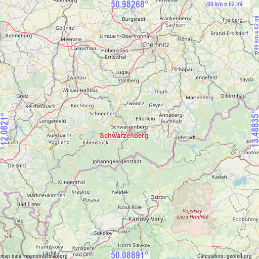
Schwarzenberg GPS coordinates[2]
50° 32' 16.476" North, 12° 47' 6.792" East
| Map corner | latitude | longitude |
|---|---|---|
| Upper-left | 50.98268°, | 12.0821° |
| Center: | 50.53791°, | 12.78522° |
| Lower-right: | 50.08891°, | 13.48835° |
| Map W x H: | 99.4×99.4 km | = 61.8×61.8mi |
| max Lat: | 55.01917° ⇑52% North |
| Schwarzenberg: | 50.53791° |
| min Lat: | ⇓48% South 47.40724° |
| min Long | Schwarzenberg | max Long |
| 5.92978° | 12.78522° | 14.98853° |
| W 90.6%⇐ | ⇒9.4% E |
Elevation
Elevation of Schwarzenberg is 467 m = 1532 ft, and this is 217.9 m = 715 ft above average elevation for this country.
| Max E: |
1256 m = 4121 ft | 15.2% |
| Schwarzenberg | 467 m 1532 ft | |
| Avg. | 249.1 m = 817 ft | |
Min E: |
-5 m = -16 ft | 84.8% |
See also: Germany elevation on elevation.city.
Geographical zone
Schwarzenberg is located in North temperate zone (between Tropic of Cancer and the Arctic Circle). Distance of this North polar circle is 1781.9 km =1107.2 mi to North.| Distance of | km | miles | from Schwarzenberg |
|---|---|---|---|
| North Pole | 4387.8 | 2726.5 | to North |
| Arctic Circle | 1781.9 | 1107.2 | to North |
| Tropic Cancer | 3013.4 | 1872.4 | to South |
| Equator | 5619.3 | 3491.7 | to South |


Nearby cities:
15 places around Schwarzenberg: (largest is in red/bold)
• Aue
8.1 km =5 mi,  316°
316°
• Beierfeld
3.1 km =1.9 mi,  6°
6°
• Bernsbach
4.4 km =2.7 mi,  343°
343°
• Bockau
7 km =4.3 mi,  273°
273°
• Breitenbrunn
7.1 km =4.4 mi,  190°
190°
• Elterlein
7.3 km =4.5 mi,  53°
53°
• Erlabrunn
9.1 km =5.7 mi,  217°
217°
• Grünhain
4.9 km =3 mi,  18°
18°
• Lauter
4.5 km =2.8 mi,  307°
307°
• Markersbach
5.4 km =3.4 mi,  92°
92°
• Pöhla
3.8 km =2.4 mi,  141°
141°
• Raschau
3.5 km =2.2 mi,  102°
102°
• Rittersgrün
6.4 km =4 mi,  174°
174°
• Scheibenberg
9 km =5.6 mi, 88°
• Zschorlau
10.1 km =6.3 mi,  288°
288°
In other languages:
- In German: Schwarzenberg/Erzgeb.
- In Italian: Schwarzenberg/Erzgeb.
- In Russian: Шварценберг
- In Chinese: 施瓦岑贝格
Sources, notices
• [Note1] Compared only with cities in Germany existing in our database
• [Src1] Map data: © OpenStreetMap contributors (CC-BY-SA)
• [Src2] Other city data from geonames.org with taken over terms of usage.
• [Src3] Geographical zone / Annual Mean Temperature by Robert A. Rohde @ Wikipedia
