Rangsdorf geodata
Rangsdorf (Brandenburg) is a seat of a fourth-order administrative division; located in Germany in Europe/Berlin (GMT+2) time zone. With population of 9,134 people, there are 1763 cities with bigger population in this country. Compared to other cities in Germany, 75.1% of cities are located further ↓South; 95.2% of cities are located further ←West and 82% of cities have higher elevation than Rangsdorf. Note1
Administrative division(s):
- Level 1: Brandenburg
- Level 3: Landkreis Teltow-Fläming
- Level 4: Rangsdorf


Rangsdorf GPS coordinates[2]
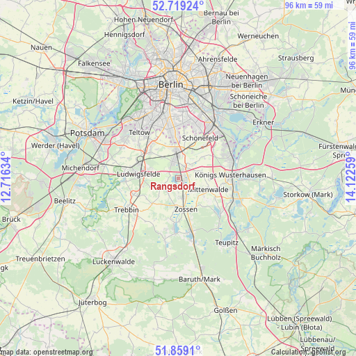
52° 17' 28.536" North, 13° 25' 10.056" East
| Map corner | latitude | longitude |
|---|---|---|
| Upper-left | 52.71924°, | 12.71634° |
| Center: | 52.29126°, | 13.41946° |
| Lower-right: | 51.8591°, | 14.12259° |
| Map W x H: | 95.6×95.6 km | = 59.4×59.4mi |
| max Lat: | 55.01917° ⇑24.9% North |
| Rangsdorf: | 52.29126° |
| min Lat: | ⇓75.1% South 47.40724° |
| min Long | Rangsdorf | max Long |
| 5.92978° | 13.41946° | 14.98853° |
| W 95.2%⇐ | ⇒4.8% E |
Elevation
Elevation of Rangsdorf is 42 m = 138 ft, and this is 207.1 m = 679 ft below average elevation for this country.
| Max E: |
1256 m = 4121 ft | 82% |
| Avg. | 249.1 m = 817 ft | |
| Rangsdorf | 42 m = 138 ft | |
Min E: |
-5 m = -16 ft | 18% |
See also: Germany elevation on elevation.city.
Geographical zone
Rangsdorf is located in North temperate zone (between Tropic of Cancer and the Arctic Circle). Distance of this North polar circle is 1586.9 km =986.1 mi to North.| Distance of | km | miles | from Rangsdorf |
|---|---|---|---|
| North Pole | 4192.8 | 2605.3 | to North |
| Arctic Circle | 1586.9 | 986.1 | to North |
| Tropic Cancer | 3208.3 | 1993.5 | to South |
| Equator | 5814.2 | 3612.8 | to South |


Nearby cities:
15 places around Rangsdorf: (largest is in red/bold)
• Altglienicke
15.5 km =9.6 mi,  30°
30°
• Am Mellensee
12.1 km =7.5 mi,  186°
186°
• Gropiusstadt
15.2 km =9.4 mi,  12°
12°
• Großbeeren
10.6 km =6.6 mi,  315°
315°
• Königs Wusterhausen
14.6 km =9.1 mi,  85°
85°
• Lichtenrade
12 km =7.5 mi,  355°
355°
• Ludwigsfelde
11.3 km =7 mi,  276°
276°
• Marienfelde
14.6 km =9.1 mi,  345°
345°
• Mittenwalde
8.9 km =5.5 mi,  113°
113°
• Rudow
15.4 km =9.6 mi,  16°
16°
• Schulzendorf
14.3 km =8.9 mi,  58°
58°
• Schönefeld
12.3 km =7.6 mi, 27°
• Wildau
14.8 km =9.2 mi,  79°
79°
• Zeuthen
15.1 km =9.4 mi,  65°
65°
• Zossen
8.6 km =5.3 mi,  166°
166°
Sources, notices
• [Note1] Compared only with cities in Germany existing in our database
• [Src1] Map data: © OpenStreetMap contributors (CC-BY-SA)
• [Src2] Other city data from geonames.org with taken over terms of usage.
• [Src3] Geographical zone / Annual Mean Temperature by Robert A. Rohde @ Wikipedia
