Altglienicke geodata
Altglienicke (Berlin) is a section of populated place; located in Germany in Europe/Berlin (GMT+2) time zone. With population of 26,426 people, there are 546 cities with bigger population in this country. Compared to other cities in Germany, 76.3% of cities are located further ↓South; 96% of cities are located further ←West and 80.6% of cities have higher elevation than Altglienicke. Note1


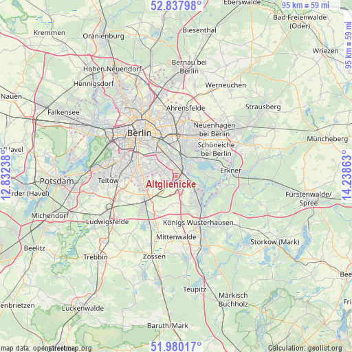
Altglienicke GPS coordinates[2]
52° 24' 40.176" North, 13° 32' 7.8" East
| Map corner | latitude | longitude |
|---|---|---|
| Upper-left | 52.83798°, | 12.83238° |
| Center: | 52.41116°, | 13.5355° |
| Lower-right: | 51.98017°, | 14.23863° |
| Map W x H: | 95.4×95.4 km | = 59.3×59.3mi |
| max Lat: | 55.01917° ⇑23.7% North |
| Altglienicke: | 52.41116° |
| min Lat: | ⇓76.3% South 47.40724° |
| min Long | Altglienicke | max Long |
| 5.92978° | 13.5355° | 14.98853° |
| W 96%⇐ | ⇒4% E |
Elevation
Elevation of Altglienicke is 45 m = 148 ft, and this is 204.1 m = 670 ft below average elevation for this country.
| Max E: |
1256 m = 4121 ft | 80.6% |
| Avg. | 249.1 m = 817 ft | |
| Altglienicke | 45 m = 148 ft | |
Min E: |
-5 m = -16 ft | 19.4% |
See also: Germany elevation on elevation.city.
Geographical zone
Altglienicke is located in North temperate zone (between Tropic of Cancer and the Arctic Circle). Distance of this North polar circle is 1573.6 km =977.8 mi to North.| Distance of | km | miles | from Altglienicke |
|---|---|---|---|
| North Pole | 4179.5 | 2597 | to North |
| Arctic Circle | 1573.6 | 977.8 | to North |
| Tropic Cancer | 3221.7 | 2001.9 | to South |
| Equator | 5827.6 | 3621.1 | to South |


Nearby cities:
15 places around Altglienicke: (largest is in red/bold)
• Adlershof
2.8 km =1.7 mi,  17°
17°
• Baumschulenweg
7 km =4.3 mi,  330°
330°
• Berlin Köpenick
4.7 km =2.9 mi,  42°
42°
• Bohnsdorf
3.2 km =2 mi,  126°
126°
• Buckow
5.6 km =3.5 mi,  294°
294°
• Eichwalde
7.4 km =4.6 mi, 131°
• Gropiusstadt
4.9 km =3 mi, 288°
• Grünau
3.1 km =1.9 mi,  79°
79°
• Johannisthal
4.4 km =2.7 mi, 333°
• Köpenick
4.6 km =2.9 mi,  34°
34°
• Niederschöneweide
5.1 km =3.2 mi,  344°
344°
• Oberschöneweide
5.6 km =3.5 mi,  350°
350°
• Rudow
3.7 km =2.3 mi, 292°
• Schulzendorf
7.3 km =4.5 mi,  144°
144°
• Schönefeld
3.3 km =2.1 mi,  221°
221°
Sources, notices
• [Note1] Compared only with cities in Germany existing in our database
• [Src1] Map data: © OpenStreetMap contributors (CC-BY-SA)
• [Src2] Other city data from geonames.org with taken over terms of usage.
• [Src3] Geographical zone / Annual Mean Temperature by Robert A. Rohde @ Wikipedia
