Königs Wusterhausen geodata
Königs Wusterhausen (Brandenburg) is a populated place; located in Germany in Europe/Berlin (GMT+2) time zone. With population of 32,513 people, there are 424 cities with bigger population in this country. Compared to other cities in Germany, 75.2% of cities are located further ↓South; 96.5% of cities are located further ←West and 86.3% of cities have higher elevation than Königs Wusterhausen. Note1
Administrative division(s):
- Level 1: Brandenburg
- Level 3: Landkreis Dahme-Spreewald
- Level 4: Königs Wusterhausen


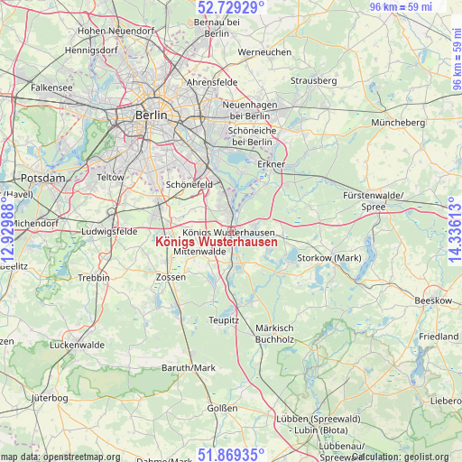
Königs Wusterhausen GPS coordinates[2]
52° 18' 5.076" North, 13° 37' 58.8" East
| Map corner | latitude | longitude |
|---|---|---|
| Upper-left | 52.72929°, | 12.92988° |
| Center: | 52.30141°, | 13.633° |
| Lower-right: | 51.86935°, | 14.33613° |
| Map W x H: | 95.6×95.6 km | = 59.4×59.4mi |
| max Lat: | 55.01917° ⇑24.8% North |
| Königs Wusterhausen: | 52.30141° |
| min Lat: | ⇓75.2% South 47.40724° |
| min Long | Königs Wusterh | max Long |
| 5.92978° | 13.633° | 14.98853° |
| W 96.5%⇐ | ⇒3.5% E |
Elevation
Elevation of Königs Wusterhausen is 32 m = 105 ft, and this is 217.1 m = 712 ft below average elevation for this country.
| Max E: |
1256 m = 4121 ft | 86.3% |
| Avg. | 249.1 m = 817 ft | |
| Königs Wusterhausen | 32 m = 105 ft | |
Min E: |
-5 m = -16 ft | 13.7% |
See also: Germany elevation on elevation.city.
Geographical zone
Königs Wusterhausen is located in North temperate zone (between Tropic of Cancer and the Arctic Circle). Distance of this North polar circle is 1585.8 km =985.4 mi to North.| Distance of | km | miles | from Königs Wusterhausen |
|---|---|---|---|
| North Pole | 4191.7 | 2604.6 | to North |
| Arctic Circle | 1585.8 | 985.4 | to North |
| Tropic Cancer | 3209.5 | 1994.3 | to South |
| Equator | 5815.4 | 3613.5 | to South |


Nearby cities:
15 places around Königs Wusterhausen: (largest is in red/bold)
• Altglienicke
13.9 km =8.6 mi,  331°
331°
• Bestensee
6.9 km =4.3 mi,  177°
177°
• Bohnsdorf
11.1 km =6.9 mi,  338°
338°
• Eichwalde
7.3 km =4.5 mi,  351°
351°
• Erkner
15.5 km =9.6 mi,  32°
32°
• Groß Köris
15.2 km =9.4 mi,  173°
173°
• Grünau
13.3 km =8.3 mi, 344°
• Mittenwalde
7.9 km =4.9 mi,  234°
234°
• Müggelheim
12.4 km =7.7 mi,  9°
9°
• Rangsdorf
14.6 km =9.1 mi,  265°
265°
• Schmöckwitz
8.3 km =5.2 mi, 7°
• Schulzendorf
6.7 km =4.2 mi, 339°
• Schönefeld
13.1 km =8.1 mi,  317°
317°
• Wildau
1.7 km =1.1 mi,  0°
0°
• Zeuthen
5.2 km =3.2 mi, 351°
Sources, notices
• [Note1] Compared only with cities in Germany existing in our database
• [Src1] Map data: © OpenStreetMap contributors (CC-BY-SA)
• [Src2] Other city data from geonames.org with taken over terms of usage.
• [Src3] Geographical zone / Annual Mean Temperature by Robert A. Rohde @ Wikipedia
