Hinsdorf geodata
Hinsdorf (Saxony-Anhalt) is a populated place; located in Germany in Europe/Berlin (GMT+2) time zone. With population of 519 people, there are 9258 cities with bigger population in this country. Compared to other cities in Germany, 69% of cities are located further ↓South; 83.9% of cities are located further ←West and 70.9% of cities have higher elevation than Hinsdorf. Note1
Administrative division(s):
- Level 1: Saxony-Anhalt
- Level 3: Anhalt-Bitterfeld
- Level 4: Südliches Anhalt


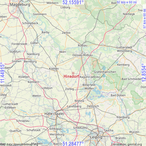
Hinsdorf GPS coordinates[2]
51° 43' 20.784" North, 12° 9' 8.172" East
| Map corner | latitude | longitude |
|---|---|---|
| Upper-left | 52.15591°, | 11.44915° |
| Center: | 51.72244°, | 12.15227° |
| Lower-right: | 51.28477°, | 12.8554° |
| Map W x H: | 96.9×96.9 km | = 60.2×60.2mi |
| max Lat: | 55.01917° ⇑31% North |
| Hinsdorf: | 51.72244° |
| min Lat: | ⇓69% South 47.40724° |
| min Long | Hinsdorf | max Long |
| 5.92978° | 12.15227° | 14.98853° |
| W 83.9%⇐ | ⇒16.1% E |
Elevation
Elevation of Hinsdorf is 86 m = 282 ft, and this is 163.1 m = 535 ft below average elevation for this country.
| Max E: |
1256 m = 4121 ft | 70.9% |
| Avg. | 249.1 m = 817 ft | |
| Hinsdorf | 86 m = 282 ft | |
Min E: |
-5 m = -16 ft | 29.1% |
See also: Germany elevation on elevation.city.
Geographical zone
Hinsdorf is located in North temperate zone (between Tropic of Cancer and the Arctic Circle). Distance of this North polar circle is 1650.2 km =1025.4 mi to North.| Distance of | km | miles | from Hinsdorf |
|---|---|---|---|
| North Pole | 4256.1 | 2644.6 | to North |
| Arctic Circle | 1650.2 | 1025.4 | to North |
| Tropic Cancer | 3145.1 | 1954.3 | to South |
| Equator | 5751 | 3573.5 | to South |


Nearby cities:
15 places around Hinsdorf: (largest is in red/bold)
• Bobbau
9.2 km =5.7 mi,  115°
115°
• Elsnigk
10.1 km =6.3 mi,  319°
319°
• Großbadegast
8.7 km =5.4 mi,  276°
276°
• Löberitz
7.6 km =4.7 mi,  182°
182°
• Prosigk
7.1 km =4.4 mi,  249°
249°
• Quellendorf
3.4 km =2.1 mi,  330°
330°
• Radegast
8.3 km =5.2 mi,  208°
208°
• Raguhn
8.6 km =5.3 mi,  98°
98°
• Salzfurtkapelle
3.6 km =2.2 mi,  149°
149°
• Schierau
9.5 km =5.9 mi,  72°
72°
• Thalheim
9.3 km =5.8 mi, 146°
• Tornau
2.1 km =1.3 mi, 102°
• Weißandt-Gölzau
7.9 km =4.9 mi,  223°
223°
• Wolfen
10.5 km =6.5 mi,  130°
130°
• Zörbig
10.7 km =6.6 mi,  193°
193°
Sources, notices
• [Note1] Compared only with cities in Germany existing in our database
• [Src1] Map data: © OpenStreetMap contributors (CC-BY-SA)
• [Src2] Other city data from geonames.org with taken over terms of usage.
• [Src3] Geographical zone / Annual Mean Temperature by Robert A. Rohde @ Wikipedia
