Quickborn geodata
Quickborn (Schleswig-Holstein) is a seat of a fourth-order administrative division; located in Germany in Europe/Berlin (GMT+2) time zone. With population of 209 people, there are 10433 cities with bigger population in this country. Compared to other cities in Germany, 92.8% of cities are located further ↓South; 62.2% of cities are located further →East and 93.9% of cities have higher elevation than Quickborn. Note1
Administrative division(s):
- Level 1: Schleswig-Holstein
- Level 3: Kreis Dithmarschen
- Level 4: Quickborn


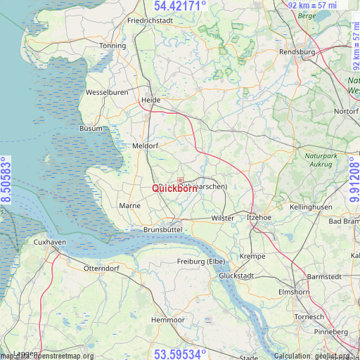
Quickborn GPS coordinates[2]
54° 0' 38.088" North, 9° 12' 32.256" East
| Map corner | latitude | longitude |
|---|---|---|
| Upper-left | 54.42171°, | 8.50583° |
| Center: | 54.01058°, | 9.20896° |
| Lower-right: | 53.59534°, | 9.91208° |
| Map W x H: | 91.9×91.9 km | = 57.1×57.1mi |
| max Lat: | 55.01917° ⇑7.2% North |
| Quickborn: | 54.01058° |
| min Lat: | ⇓92.8% South 47.40724° |
| min Long | Quickborn | max Long |
| 5.92978° | 9.20896° | 14.98853° |
| W 37.8%⇐ | ⇒62.2% E |
Elevation
Elevation of Quickborn is 11 m = 36 ft, and this is 238.1 m = 781 ft below average elevation for this country.
| Max E: |
1256 m = 4121 ft | 93.9% |
| Avg. | 249.1 m = 817 ft | |
| Quickborn | 11 m = 36 ft | |
Min E: |
-5 m = -16 ft | 6.1% |
See also: Germany elevation on elevation.city.
Geographical zone
Quickborn is located in North temperate zone (between Tropic of Cancer and the Arctic Circle). Distance of this North polar circle is 1395.8 km =867.3 mi to North.| Distance of | km | miles | from Quickborn |
|---|---|---|---|
| North Pole | 4001.6 | 2486.5 | to North |
| Arctic Circle | 1395.8 | 867.3 | to North |
| Tropic Cancer | 3399.5 | 2112.4 | to South |
| Equator | 6005.4 | 3731.6 | to South |


Nearby cities:
15 places around Quickborn: (largest is in red/bold)
• Aebtissinwisch
6.9 km =4.3 mi,  135°
135°
• Brickeln
1.7 km =1.1 mi,  66°
66°
• Buchholz
2.7 km =1.7 mi,  158°
158°
• Burg
3.6 km =2.2 mi,  114°
114°
• Ecklak
7.7 km =4.8 mi,  150°
150°
• Eggstedt
5.8 km =3.6 mi,  40°
40°
• Frestedt
3 km =1.9 mi,  326°
326°
• Großenrade
1.5 km =0.9 mi, 36°
• Gudendorf
6.8 km =4.2 mi,  282°
282°
• Hochdonn
4.7 km =2.9 mi, 67°
• Krumstedt
6.5 km =4 mi,  344°
344°
• Kuden
5.2 km =3.2 mi,  198°
198°
• Sankt Michaelisdonn
6.8 km =4.2 mi,  243°
243°
• Süderhastedt
4.3 km =2.7 mi,  358°
358°
• Windbergen
7.5 km =4.7 mi,  306°
306°
Sources, notices
• [Note1] Compared only with cities in Germany existing in our database
• [Src1] Map data: © OpenStreetMap contributors (CC-BY-SA)
• [Src2] Other city data from geonames.org with taken over terms of usage.
• [Src3] Geographical zone / Annual Mean Temperature by Robert A. Rohde @ Wikipedia
